Tag Archives: Spectra Energy

Crowdsourcing pictures of Sabal Trail path

Update 2016-11-29: Added to this google map: WWALS aerials of Gilchrist County, and Sabal Trail alignment maps localized by LAKE for Mitchell, Colquitt, Brooks, and Lowndes Counties, Georgia, and Hamilton, Suwannee, and Gilchrist Counties, Florida to just north of Bell, FL.

Update 2016-11-04: Now with Sabal Trail route digitized through Gilchrist, Alachua, and part of Levy Counties, plus part of the Citrus County line.

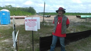
Signs, silt fences, backhoes in wetlands: you can log pictures on a map of anything going on at a Sabal Trail construction site from your mobile phone, tablet, or laptop. Already posted your pictures on the web? Link them into the map. Here’s how.

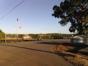
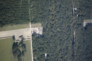
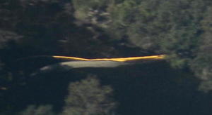
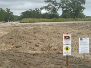
You’ve seen many pictures posted by WWALS, taken on the ground and in the air, and linked into a google map (which also has Sabal Trail’s alignment maps linked in).

Here’s another google map, to which more people can add pictures.

If you want to add pictures to this new crowdsourcing google map, you need to: Continue reading

US 129 HDD Santa Fe River Sabal Trail 2016-10-22

South to North HDD, 29.9122530, -82.8515280 Sabal Trail plans to start drilling here in the next few days. I count three houses within the blast radius just in this picture at the Santa Fe River just east of US 129 in Suwannee and Gilchrist Counties, Florida. See also Jim Tatum’s pictures of this Santa Fe River Sabal Trail HDD location from this flight. Continue reading

From the air: US 84 HDD Withlacoochee River Sabal Trail 2016-10-22

Update 2016-10-24: Questions filed with FERC in Docket CP15-17 as Accession Number 20161024-5049 and emailed to USACE and GA-EPD (PDF).

Extreme closeup yellow in Withlacoochee River, 30.7952780, -83.4524840 What is that yellow thing in the river, Sabal Trail? Is that a sinkhole you’ve marked at the Lowndes County HDD site? And does blue pipe mean thinner for rural areas like your executive from Houston told us in WWALS v Sabal Trail & FDEP?

FERC gave you permission to Continue reading

Sabal Trail requests variance to Colquitt County, GA creek 2016-10-17

Monday Sabal Trail asked FERC to add a contractor yard in Colquitt County, and to change routing under a small stream. No rush: Sabal Trail wants approval by tomorrow, Thursday, October 20th 2016. Presumably because they’re racing hell-for-leather to meet their May 2017 in-service drop-dead date, after which (according to FPL’s RFP) they could forfeit a $200 million bond or lose the contract.

Here, courtesy of Lowndes Area Knowledge Exchange (LAKE), are Sabal Trail’s October 17th 2016 maps of that stream, plus Sabal Trail’s April 2016 maps of where it wants to cross the stream it flows into, Hog Creek and that stream’s downstream Okapilco Creek.

We’ve already seen where Sabal Trail is drilling under the Withlacoochee River between Valdosta and Quitman, Georgia and under the Suwannee River in Suwannee River State Park. Plus there’s an encampment of water protectors in Suwannee County.

Contractor Yard CY3-6

Continue reading

Encampment against Sabal Trail in Suwannee County, FL

According to Gregory Payne, Sabal Trail only recently put up those No Trespassing signs on their easement, Gregory Payne outside Sabal Trail No Trespassing zone after Gregory moved in with a peaceful nonviolent encampment with permission from the landowner. While trying to stop the pipeline, the campers are making sure Sabal Trail does not block the landowner’s access. This is not a WWALS event or activity, but it is happening in WWALS watersheds, so I went to report on it yesterday, Sunday October 16th 2016.

Gregory Payne says Continue reading

WWALS at Suwannee River Roots Revival 2016-10-15

Music and advocacy on the banks of the iconic Suwannee River!

Gretchen Quarterman and Dave Hetzel by Leeann Drabenstott Culbreath WWALS outings, rivers, Valdosta wastewater, agricultural runoff, and the issue half the people wanted to talk about was the Sabal Trail fracked methane pipeline: nobody wants it.

Thanks to Leeann Drabenstott Culbreath for the great picture of WWALS Treasurer Gretchen Quarterman and Ambassador Dave Hetzel, who engages everybody who walks past. Thanks to WWALS member Bret Huntley for camping overnight last night and setting up this morning. Gretchen took the other pictures of Dave and Bret. WWALS president John S. Quarterman took the one of the Shook Twins on the Amphitheater Stage in Spirit of Suwannee Music Park at Suwannee River Roots Revival on the banks of the Suwannee River.

Come on down to these upcoming WWALS events and outings: Continue reading

Rush Hour Rally at FPL HQ to Stop Sabal Trail Pipeline 2016-10-14

Taking it to the source: the headquarters of FPL, whose ratepayers are on the hook for $3 billion for the Transco → Sabal Trail → FSC fracked methane pipeline boondoggle through Alabama, Georgia, and Florida, Sierra Club and Indian Riverkeeper are holding a Rush Hour Rally this Friday, October 14th 2016 in Juno Beach, Florida; see press release for details. If you can’t get there, there are other events all over Florida and beyond. Remember, FPL admits no need for new electricity until 2024, so there’s no more excuse for Sabal Trail.

At FPL HQ, Juno Beach, FL

The facebook page Protect Florida Against Sabal Trail attempts to keep track of upcoming rallies against Sabal Trail or its ugly stepsisters, which are popping up practically daily. Here are some events scheduled starting this weekend: Continue reading

All 527 Sabal Trail alignment maps from April 2016

Courtesy of Lowndes Area Knowledge Exchange, you can now see small, big, huge, and PDF versions of all 527 alignment maps Sabal Trail filed with FERC in April 2016: follow this link.

[STA. 11870+00 TO STA. 11923+00, (UT OKAPILCO CREEK), 11881+44 CL SPAIN ROAD, 11871+70 CL GOLDING ROAD, BROOKS COUNTY, GEORGIA]

Having these maps online like this makes it easier to see what’s in them. Sabal Trail told FERC Okapilco Creek was not among the streams for which the Georgia legislature denied river-drilling easements (and for which Sabal Trail got the easements later anyway by suing the state in county Superior Courts). Yet Sabal Trail’s alignment maps from April 2016 seem to say that fracked methane pipeline crosses Okapilco Creek a couple of times in Brooks County, Georgia.

Here’s one of those times, in which the road names don’t match Continue reading

Sabal Trail begins at Hillabee Power Plant

Where Sabal Trail connects to Transco: the head of the black snake, Sabal Trail, Hillabee Power Plant, Exelon Corp., Brick Plant Rd., 33.0045260, -85.9051100 at Hillabee Power Plant, owned by Exelon Corp., near Alexander City, Alabama. We were driving by, so we took some pictures. Here are Sabal Trail’s Alignment Maps for this area, the photographs I took yesterday, and a google map with links to the pictures, plus what you can do to stop this unnecessary, destructive, and hazardous fracked methane pipeline boondoggle.

Update 2016-10-10: All 527 of Sabal Trail’s April 2016 alignment maps are now available in small, big, huge, and PDF formats, courtesy of Lowndes Area Knowledge Exchange (LAKE).

What you can do

Continue reading