Tag Archives: spring

Dye test in Dead River Sink on Alapaha River

Update 2016-06-22: Dye test into the Dead River Sink: it came back up several days later and eighteen river miles south, in the Alapaha River Rise and Holton Bluff Spring, both on the Suwannee River.

The Alapaha River disappears underground in dry seasons, and nobody has ever known where it comes back up. Soon, we will know.

Green Publishing, 16 June 2016, Dye test held for river basins,

The Florida Geological Survey will be conducing a dye test for the Suwannee River Water Management District in the Upper Suwannee/Alapaha River basins later this month. They will introduce dye into the Dead River Swallet (swallets are sinkholes that capture flow) and a swallet that is located on privately owned land. They will also have sampling devices setup at Continue reading

Sabal Trail reacts to Sanford Bishop GA-02, WWALS, Price P.G.

It’s time for more people and organizations, especially Congress members, to ask the Corps for a Supplemental Environmental Impact Statement, after Sabal Trail side-stepped many of the questions Cover letter in a 130-page claim that it had already addressed every recent point from U.S. Rep. Sanford Bishop GA-02, WWALS Watershed Coalition, Flint Riverkeeper, and Dennis Price P.G. in recent letters to the U.S. Army Corps of Engineers. 
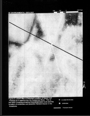
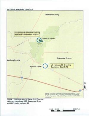
If karst concerns alone were enough to move Sabal Trail off of the Withlacoochee River in Florida, and the Itchetucknee River, and to move it to a different crossing for the Santa Fe River, they should be enough to move it off the Suwannee River, where the conditions are quite similar.

In case anybody wondered whether Sabal Trail is watching the web for anything posted by its opponents, note where Sabal Trail said in its included 6 June 2016 letter to Mark R. Evans of the Corps that it first saw Sanford Bishop’s letter: Continue reading

4610 foot explored cave at McIntyre Spring, Withlacoochee River, Georgia

Did you know there’s an almost mile-long cave system under the Withlacoochee River between Lowndes and Brooks Counties, Georgia? Valdosta cave-diver Guy Bryant wrote a fascinating in-depth blog about McIntyre Spring, including this map he drew, and the picture below of him in this cave system that starts in the river bottom.

There’s no land access, so don’t trespass. And don’t try to go in the cave even from boats unless you really know what you’re doing. It’s been visited by some of the most famous cave divers in the world, a couple of whom are no longer with us due to accidents in other underground caverns.

But do please go read Guy Bryant’s blog post. Continue reading

Leadership is supporting the county’s own people against the Sabal Trail invader –WWALS in Suwannee Democrat

In the paper Suwannee Democrat, May 5th, 2016.

A company from Houston, Texas wants to fill our earth, water, and air with violence. WWALS Watershed Coalition showed Suwannee County Commissioners sinkholes in the middle of the pipeline path that Sabal Trail didn’t mention to the Federal Energy Regulatory Commission (FERC). All of them, except Jason Bashaw, studied a report by a local geologist and showed leadership by voting to tell that “truth that exists in the middle” to the U.S. Army Corps of Engineers.

The quotation above is a reference to Continue reading

FERC makes Hamilton BOCC filing illegible

Does FERC actually look at what counties and other people send it?

Figure 2: LiDAR Map, Suwannee River --Dennis Price to FERC (5 of 8) FERC made the figures illegible in its posting of Dennis Price’s geology report that Hamilton BOCC appended when it forwarded to FERC its site visit request to the U.S. Army Corps of Engineers.

This reminds me of when FERC lost half of Dougherty County’s Sabal Trail resolution and just happened to lose page 3 of Bill Kendall’s letter, the page about lack of need, false pretense, and duress. Does FERC actually care what anybody thinks, other than the industries it “regulates” while they pay all its costs?

FERC Filing 28 March 2016, Accession Number 20160328-0091, “Correspondence from Board of County Commissioners of Hamilton, FL to U.S. Army Corp of Engineers re the Environmental Geology report under CP15-17.” Continue reading

Geological determinations about Sabal Trail and Suwannee River by Dennis Price P.G.

Sinkholes, springs, and caves abound where Spectra Energy wants to gouge its yard-wide Sabal Trail pipeline Figure 1. Location Map of Sabal Trail Pipeline through the heart of the Florida Springs Heartland, wrote a Practicing Geologist WWALS member to FERC, following up on his testimony in WWALS v Sabal Trail & FDEP.

Here is the text of the report by Dennis Price, followed by the images (PDF in FERC accession number 20151027-5034), all about the same area where WWALS board member Chris Mericle recently guided Hamilton and Suwannee County Commissioners to see for themselves. -jsq

Continue reading

Audubon speaks for the Florida legislature now?

Even as Our Santa Fe River and others held a demonstration in Gainesville yesterday against fracking bills in the Florida legislature, especially Senate Bill 318 now that House Bill 191 passed, Audubon Florida published a letter concluding:

“So my request to you right now: hold off of the emails to the committee, they know you are paying attention.”

This has not sit well with many opponents of fracking in Florida. WWALS is among the members of Floridians Against Fracking that call for Floridians to call their state legislators.

WWALS remembers when Continue reading

Sabal Trail pipeline challenged by recommended order, plus Suwannee County resolution tonight

FOR IMMEDIATE RELEASE

Sabal Trail pipeline challenged by recommended order, plus Suwannee County resolution tonight

Jasper, Florida, November 17, 2015 — The day after WWALS filed its Proposed Recommended Order (PRO) in WWALS v. Sabal Trail & FDEP saying FDEP didn’t do proper due diligence on what Sabal Trail’s application, especially for the Outstanding Florida Waters of the Suwannee River and the Santa Fe River, the Suwannee County Commission is considering tonight a resolution against Sabal Trail’s proposed Hildreth Compressor Station.

Suwannee County resident Debra Johnson remarked,

“How about nowhere in our county. It’s like who wants this dangerous compressor station in Suwannee County ANYWHERE?”

David Shields testified at the hearing in Jasper that he had purchased land in Suwannee County because: Continue reading

WWALS files Proposed Recommended Order with DOAH 2015-11-16

DEP failed to sufficiently review or verify Sabal Trail’s application, failed to timely place comments from affected landowners in the public record, and disregarded heightened protection requirements of Florida Outstanding Waters. Sabal Trail admitted Spectra Energy is its operator in perpetuity, and that horizontal directional drilling could adversely affect water quality of the Suwannee River, yet DEP failed to adequately consider such effects. DEP professed to be unaware of other potential risks such as crossing existing pipelines, including the Southern Natural Gas pipeline. Springs, fragile karst geology, leaks, LiDAR, and geologic collapse: all insufficiently considered by DEP. Sinkholes, springs, and gopher tortoises pointed out by landowners never examined by Sabal Trail or DEP.

A Spectra Energy executive from Houston deigned to come to “the middle of nowhere” to tell us they’d use thinner pipe in low population areas such as Suwannee County. He testified at length about Spectra’s safety history, even Continue reading

Pictures: Sullivan Launch to Madison Blue Spring Withlacoochee River 2015-10-24

Update 2022-07-20: better picture labels and access.

A fine day, balmy, breezy, sunny, with springs and rapids and fine company, Onwards from Hardee Spring 30.5444069, -83.2500076 from Sullivan Launch to Madison Blue Spring on the Withlacoochee River, in the October WWALS Outing, October 24, 2015. This is part of the Withlacoochee and Little River Water Trail, and you can join the committee!

Below are some pictures. Click on any small picture to see a larger version. Pictured: many shoals and rapids. The Pinetta gage (pictured) read 6.4 feet. Any lower and more dragging boats would have been necessary. Lots of cypress, oaks, pines, and other native species.

Pinetta Gage steps and old-style measure 30.5957374, -83.2598038 Not pictured: a large turtle, numerous birds (heron, ibis, hawk, buzzard, others), and fish (mullet, bass). No gators. Very few invasive species, except the notorious Japanese climbing fern.

Coming up next: Continue reading