Tag Archives: Suwannee River

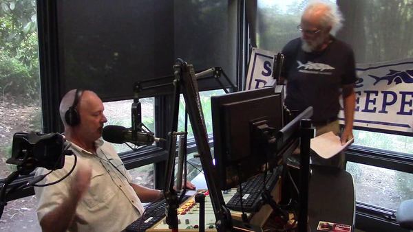
Video: Paddle races, water trails, and Sabal Trail jury trials; Suwannee Riverkeeper on WGOV Radio 2018-09-13

Thanks to Steve Nichols for having me on The Morning Drive with Steve Nichols, 105.9FM WVGA. We talked about water trails, paddle races, and the Sabal Trail pipeline federal eminent domain jury trials, which were being settled as we spoke. Also we hear the Naylor Boat Ramp will be finished soon by Lowndes County.

On air, Movie

As I asked Steve about the three jury trials:

This is about federal eminent domain for the Sabal Trail pipeline.

SN: That’s right.

Now they already built the pipeline. But for these landowners, they sued them for the eminent domain. They do not have a written agreement with the landowners. They have not paid them a cent. But they already built the pipeline. Does that sound right to you? Continue reading

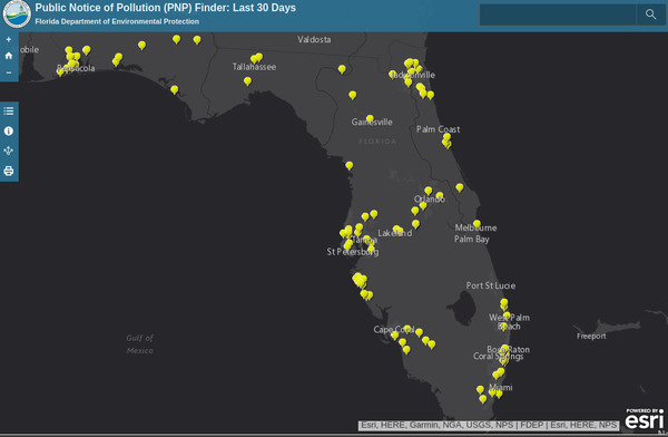
FDEP now maps last 30 days of spills

Pollution spill maps online, up to date, with interactive links to details: Florida is doing it, and so can Georgia.

Florida, Maps

For more than a year FDEP has been posting spill reports online in a spreadsheet the same day it gets them, with email notice signup (Alabama also does that). FDEP has added a Public Notice of Pollution (PNP) Finder: Last 30 Days, which helps a lot in finding spills in our watersheds.

Did you know there was a Phosphoric Acid spill at White Springs last week, on Continue reading

Tour of Valdosta wastewater treatment plants 2018-10-03

WWALS will tour Valdosta’s Wastewater Treatment Plants (WTPs). Thanks to Scott Fowler and Director Darryl Muse for the longstanding invitation. WWALS invites you to come, from both Georgia and Florida, especially people downstream on the Withlacoochee, Alapaha, or Suwannee Rivers.

When: 9AM, Wednesday, 3 October 2018

Where: Valdosta Utilties, 1016 Myrtle Street, Valdosta, Georgia 31601
The Myrtle Street off of E. Force Street between Troup and Forrest (not the one in Remerton).

Event: facebook, meetup

Valdosta's Mud Creek WTP

Where: We will go to the Withlacoochee WTP next to the Withlacoochee River, and the Mud Creek WTP on Knights Creek, upstream from Mud Creek, the Alapahoochee River, and the Alapaha River. We may go to other points such as force mains or lift stations. If we have time we will also tour Valdosta’s drinking water treatment plant.

Duration: Probably several hours, but should be done by noon.

Free: There is no charge. This tour is primarily for WWALS members, but we won’t turn away anybody else and I doubt Valdosta will, either. We do recommend you join WWALS today.

Why: For why so many people are interested in Valdosta’s WTPs and what Valdosta has done to date, see Valdosta (and other) Wastewater.

This is not a regular WWALS outing or event, but for more WWALS outings and events as they are posted, see the WWALS calendar or the WWALS outings and events web page. WWALS members also get an upcoming list in the Tannin Times newsletter.

 -jsq, John S. Quarterman, Suwannee RIVERKEEPER®

You can join this fun and work by becoming a WWALS member today!

Suwannee Riverkeeper on Steve Nichols radio 105.9FM WVGA 2018-09-13

Thursday morning Suwannee Riverkeeper will be on the “top rated morning talk show in south Georgia” with Steve Nichols, talking about paddle outings, water trails, paddle races, and the Sabal Trail pipeline federal eminent domain jury trials going on right now in Valdosta.

When: 8:30AM, Thursday, September 13, 2018,

Where: The Morning Drive with Steve Nichols, 105.9FM WVGA
Live streamed on the show’s facebook page

Event: facebook, meetup

Suwannee Riverkeeper banner, Interview

What:

Guest: Suwannee Riverkeeper® John S. Quarterman

Host: Valdosta Today bills The Morning Drive with Steve Nichols as:

The top rated morning talk show in south Georgia, Steve Nichols offers both sides of every story from Berrien County to the Beltway, and everywhere in between.

Should be fun. Do tune in.

More: For more WWALS outings and events as they are posted, see the WWALS calendar or the WWALS outings and events web page. WWALS members also get an upcoming list in the Tannin Times newsletter.

 -jsq, John S. Quarterman, Suwannee RIVERKEEPER®

You can join this fun and work by becoming a WWALS member today!
Cyanobacteria infecting Florida political races

We are fortunate in the Suwannee River Basin in not having this bad a problem, but are similarities. Greg Allen, NPR, 7 September 2018, Toxic Algae Seeps Into Florida Congressional Races,

For months now, mats of algae from Lake Okeechobee have been flowing down the river, bringing toxins that can affect people and animals. In beach communities east of the lake, the algae have had a big impact on tourism and businesses.

With more toxic algae blooms on Florida’s west coast and a red tide algae bloom causing massive fish kills in the Gulf of Mexico, water quality is increasingly having a big impact on key midterm races in Florida. While Democrats tend to be more outspoken on environmental issues, Republican candidates are also speaking up because they’re feeling the heat.

Outflows from Lake Okeechobee

Seems to me all the candidates are dancing around the real issue, which is Continue reading

Bradford BOCC 2018-09-04

All the public speakers were against the phosphate mine. Before the Commissioners decided, Merrillee Malwitz-Jipson spoke about rain, the Chemours mine, and how what Bradford County does affects her business downstream. (I think Stasia Rudolph also spoke before I got there.) After some confusion on timing, afterwards Marc Lyons reminded them Citizens Against Phosphate Mines (CAPM) is ready to sue, and Kate Ellison said she hopes this means we will all see the consultant’s report before the public hearings. I sent a letter and a resolution the previous day and gave them paper copies.

The actual decision was much better than expected. While some Commissioners wanted to hold Continue reading

Big Georgia Wastewater Permits in the Suwannee River Basin

Update 2021-03-18: Plus Moody Air Force Base.

Update 2021-03-17: Now with Ray City added 2021-03-15 and Lakeland added 2021-03-17.

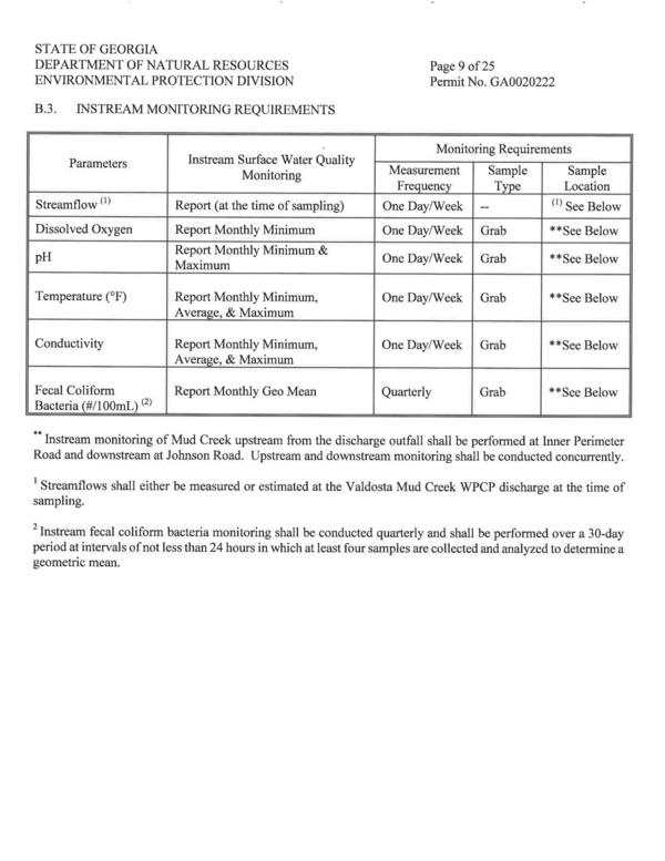
Schedules of testing, with permissable levels: these are in National Pollutant Discharge Elimination System (NPDES) wastewater permits, so we need to see those permits. You’d think they’d be on the EPA or GA-EPD website, but….

The U.S. EPA has delegated NPDES permitting to Georgia. You can get draft wastewater permits right off the GA-EPD website, but to get the actual current approved permits, you must get GA-EPD to send them to you. I found this out from Audra Dickson, Wastewater Regulatory Program Manager. I asked her for permits for half a dozen cities and one county, and the next day Alyssa Thomson, Environmental Specialist, Wastewater Regulatory Program, Municipal Permitting Unit, sent them via email.

They’re on the WWALS website now.

Instream Monitoring Requirements, Valdosta Mud Creek WPCP

Why this list? Continue reading

Valdosta Consent Order from GA EPD 2013-09-23

Update 2020-04-15: See much longer and more recent version of the Consent Order, in Valdosta Sewer System Standard Operating Procedures 2020-03-05.

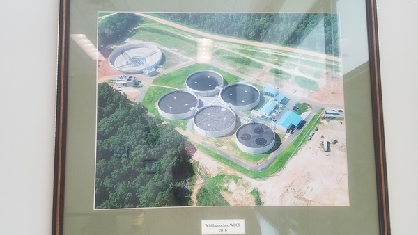
Due to tens of millions of dollars spent by Valdosta, we don’t see spills of tens of millions of gallons anymore. The most obvious Valdosta Sanitary System Improvement is the new, uphill, out of the flood plain, Withlacoochee Wasterwater Treatment Plant, pictured here on Scott Fowler’s office wall at Valdosta Utilities:

Withlacoochee WPCP 2016, Wastewater Plants
Withlacoochee WPCP 2016

The old, now-closed, Withlacoochee WTP was the plant that had the biggest problems back in 2009 and 2013. As found on the City of Valdosta website, the 23 September 2013 Valdosta Consent Order from the Georgia Environmental Protection Division is now also on WWALS website, including I made a web version, from which I extracted the paragraphs quoted below.

This was the original problem: Continue reading

Paddle Georgia discovers the Withlacoochee River

Would you like to paddle the Withlacoochee and Suwannee Rivers for a week in June 2019 with 300 of your closest friends? Our rivers topped Paddle Georgia’s poll of six destinations. Joe Cook, Mr. Paddle Georgia, called me back in July about this possibility. That’s why on July 5, 2018, I blogged A week on the Withlacoochee River in June?

Shoals on the Withlacoochee River
Paddle Georgia discovering the Withlacoochee River has rapids.

It turns out there was a story in the Continue reading

Rivers bigger and more important that previously thought 2018-06-28

Rivers and streams cover more of the earth’s surface than previously thought, and likely interchange more CO2 and other gases with the atmosphere than previously thought. WWALS Science Committee Chair Tom Potter found this paper.

George H. Allen and Tamlin M. Pavelsky, Science, 28 Jun 2018, DOI: 10.1126/science.aat0636 Global extent of rivers and streams,

Abstract

The turbulent surfaces of rivers and streams are natural hotspots of biogeochemical exchange with the atmosphere. At the global scale, the total river-atmosphere flux of trace gasses such as CO2 depends on the proportion of Earth’s surface that is covered by the fluvial network, yet the total surface area of rivers and streams is poorly constrained. We used a global database of planform river hydromorphology and a statistical approach to show that global river and stream surface area at mean annual discharge is 773,000 ± 79,000 km2 (0.58 ± 0.06%) of Earth’s non-glaciated land surface, an area 44 ± 15% larger than previous spatial estimates. We found that rivers and streams likely play a greater role in controlling land-atmosphere fluxes than currently represented in global carbon budgets.

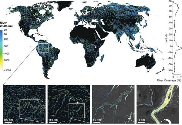
Fig. 1. Global River Widths from Landsat (GRWL) Database, Figure
Fig. 1. The Global River Widths from Landsat (GRWL) Database contains more than 58 million measurements of planform river geometry. The line plot on the right shows observed river coverage as a percentage of land area by latitude, and the bottom insets show GRWL at increasing zoom. The rightmost inset shows GRWL orthogonals over which river width was calculated, with only every eighth orthogonal shown for clarity.

You can see the lower Suwannee River in the above figure.

The authors zoom in on the Amazon River Basin in Brazil, but those last two zooms could easily be Continue reading