Yesterday morning the smoke was thick at Lakeland Boat Ramp on the Alapaha River, and smokey haze continued all the way past Waycross to Okefenokee Swamp Park.
Rain a few days ago helped, but it was only a few inches, and fires can smolder for many days.
More rain is predicted for four days starting today: maybe that will finally put that fire out, and the many others.
Meanwhile, don’t burn outdoors, eh?
![[Smoke at Lakeland Boat Ramp, Pineland Road Fire 2026-05-06, Suwannoochee Creek, Suwannee River Basin]](https://www.wwals.net/pictures/2026-05-06--smoke-lakeland-boat-ramp/many.jpg)
Smoke at Lakeland Boat Ramp, Pineland Road Fire 2026-05-06, Suwannoochee Creek, Suwannee River Basin
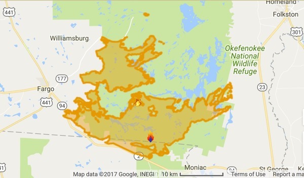
The smoke was probably mostly from the Pineland Road Fire in Clinch and Echols Counties. The creek in its middle is Suwannoochee Creek, which is the county line and runs into the Suwannee River downstream from Fargo.
Here’s the big picture. Continue reading
![[Wildfire map, --watchduty.org 2026-04-20, Suwannee River Basin, Numerous wildfires]](https://www.wwals.net/pictures/2026-04-20--watchduty-fire-map/many.jpg)
![[Please deny the mining permits]](https://www.wwals.net/pictures/2023-03-17--wwals-to-epd-tpm-okefenokee/many.jpg)
![[WKUB 105.1 FM]](https://www.wwals.net/pictures/2020-06-04--wkub-brian-blount-okefenokee-swamp-titanium-mine/155477_328832620516056_198958454_n.jpg)
![[Okefenokee Swamp sign at I-75 exit 16.]](https://www.wwals.net/pictures/2020-05-22--wwals-vdt-deadlines-tpm-usace-vld-ga-epd/crop-oke-sign.jpg)