Category Archives: Quantity

Local recharge through sinkholes and drainage wells moves underground

With the artesian level as much as 100 feet above sea level and the land surface is seldom more than 200 feet, a Sabal Trail pipeline drilling frac-out wouldn’t have to go far to get into the Floridan Aquifer groundwater used by wells around here. We already saw such water contamination would go underground is hard to predict. This is not news: here’s a paper from 1966 with the main points.

Artesian Water in Tertiary Limestone in the Southeastern States, By V. T. Stringfield, GEOLOGICAL SURVEY PROFESSIONAL PAPER 517, 1966. Continue reading

Petition GA Gov. Deal to oppose Sabal Trail pipeline

Please sign this petition to Please Ban The Sabal Trail Fracked Gas Pipeline.

Congratulations to Push Back the Pipeline for convincing GA Gov. Deal and Lt. Gov. Cagle to oppose Kinder Morgan’s Palmetto Project and the Georgia Dept. of Transportation to deny KMI a permit.

Now it’s time for the same for the Sabal Trail Pipeline. The permitting process is different, but opposition from the state of Georgia could stop this invader, too.

While Sabal Trail has moved off our Withlacoochee River in Florida, it still wants to cross the Withlacoochee in Georgia at the Continue reading

WWALS Goals for 2015

Boating on our rivers and water trails for them, issues and education: you can help with the fun and work of WWALS! Here’s much of what can be done laid out in a list of a dozen WWALS Goals for 2015. The board has at least one opening right now, and the committees always could use more members. You can apply through the online form.

See also the monthly newsletter, the news about WWALS, and of course the website with blog, facebook the page and group, and WWALS on twitter, Youtube, and the membership google group. You can become a member or corporate sponsor of WWALS online right now.

The WWALS Executive Committee 11 March 2015 recommended Continue reading

Douglas meeting of Suwannee-Satilla Regional Water Planning Council 2015-06-15

WWALS Ambassador Dave Hetzel will be speaking at this meeting (PDF). 300x194 Douglas and Coffee County, Satilla and Willacoochee Rivers, in Douglas meeting of Water Council, by Suwannee-Satilla Regional Water Planning Council, for WWALS.net, 15 June 2015

Douglas is in the Satilla River watershed, but WWALS’ Willacoochee River forms the border between Coffee County and Berrien County.

NOTICE:

SUWANNEE-SATILLA
REGIONAL WATER PLANNING COUNCIL MEETING

Announcement Date: May 28, 2015

TO ALL INTERESTED PERSONS AND PARTIES:
The Suwannee-Satilla Regional Water Planning Council is holding its next meeting
at the following date, time, and location: Continue reading

EPA Clean Water Rule finalized

I still see EPA’s new Clean Water Rule as a good thing, since it protects drinking water, paddling, and fishing, while opponents remain quite vague about what might be wrong with it.

After last year’s comment period, U.S. EPA has posted a prepublication version of its final Clean Water Rule.

Katie Shepherd, L.A. Times, 27 May 2015, Under new EPA rule, Clean Water Act protections will cover all active tributaries, Continue reading

Linkage between ground water and surface water –USGS

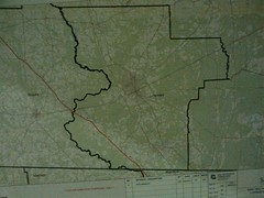
Yet more documentation on why gouging a pipeline under the Withlacoochee River, 
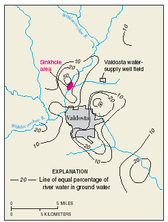
or through this Valdosta Limesink area anywhere, would be a bad idea:

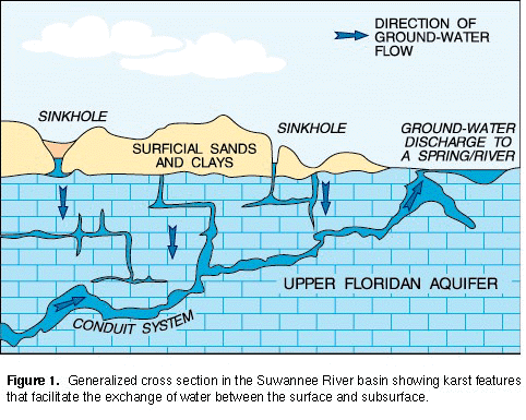
In most watersheds (river basins) in Florida the interactions between ground water and surface water typically result in a single dynamic flow system. This direct hydraulic linkage results from numerous karst features (such as sinkholes, conduit systems in the underlying limestone, and springs) that facilitate the exchange of water between the surface and subsurface (fig. 1). Unique problems can arise in protecting water quality in karst areas because of the direct and rapid transport of recharge through conduits to the subsurface and through resurgence by springs. In some areas, recharge from unknown drainage pathways to areas of discharge may contribute to chemical and biological contamination of water supplies. Such contamination in karst areas has been documented by many studies.

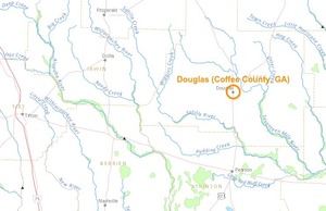
Yes, it says Florida, but the geology doesn’t stop at the state line, as USGS spelled out in a 1999 study of the Withlacoochee River. It works like this in Georgia, too: Continue reading

Pictures: Rowetown Church to GA 135 –Bret Wagenhorst

Expedition leader Bret Wagenhorst’s always-excellent pictures of the 18 April 2015 WWALS Outing on the Alapaha River Water Trail.

And don’t forget coming up May 16th theThird annual BIG Little River Paddle Race at Reed Bingham State Park on the Little River. Continue reading

Alapaha River precipitation and levels

300x153 90 Days Levels Graph, in Alapaha River Levels and Precipitation, by USGS, for WWALS.net, 7 March 2015 Rainfall can be quite different in Statenville on the Alapaha River as shown here than in Valdosta on the Withlacoochee River. But remember half of Valdosta drains into the Alapaha River watershed.

Here are rainfall and water level graphs from the three USGS Alapaha River gauges in Georgia. The Florida gauge is shown separately, because it use a different base level, and precipitation doesn’t seem to be available from Florida gauges. See also always-current graphs of all the levels. Continue reading

Withlacoochee River levels follow rainfall

300x153 7 days Precipitation Graph, in Withlacoochee River Gauges, by NWS, for WWALS.net, 7 March 2015 Plus early March rains really were directly on Valdosta, even more than in Valdosta’s third wastewater spill of February, yet river levels rose most downstream.

Here are 90-day graphs of precipitation (in inches) and river levels (in feet) at the three Georgia Withlacoochee River gauges, from USGS. Also note river levels can continue dropping even while some new rain falls. Continue reading

Spring Flood Potential Outlook for Withlacoochee River by NWS

There is potential for “a high impact basin-wide flood event this spring should heavier than normal rainfall occur” in the Withlacoochee Basin.

300x233 Vdsg1 Hg Skipper Bridge, in Withlacoochee River Gauges, by NWS, for WWALS.net, 7 March 2015 National Weather Service Tallahasee, FL 240 PM EST THU MAR 5 2015, Spring Flood Potential Outlook for Southeast Alabama, Southwest and South Central Georgia, and the Florida Panhandle and Big Bend,
Above normal potential for river flooding this Spring,
Existing Conditions.

In the Withlacoochee, Suwannee Basin…

Continue reading