Tag Archives: pipeline

CY3-6 full less than a day after FERC approval: Sabal Trail Moultrie contractor yard 2016-10-22

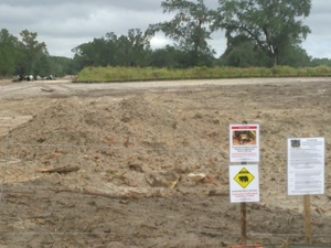
Less than a day after FERC rubberstamped (or did it?) Sabal Trail’s request for a new contractor yard on the east side of Moultrie, Georgia, WWALS saw that yard already full of materials. Did Sabal Trail really move everything in that fast, or were those things already there, like the notorious Lake City, Florida pipe yard that never has gotten any formal FERC approval that we’ve seen?

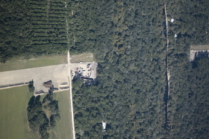
Here’s what we saw from the Southwings flight for WWALS on Saturday October 22nd 2016:

CY3-6 area of Sabal Trail overview map

Compare with the overview map Sabal Trail filed with its request to FERC of Monday October 17th 2016: Continue reading

Waterkeeper Alliance asks Obama to halt DAPL

WWALS has been tying #NoDAPL to #NoSabalTrail for some time, because water protectors here continue to fight Sabal Trail for many of the same reasons as the Standing Rock Sioux fight the Dakota Access Pipeline, plus one of the DAPL pipeline companies, Enbridge, is buying Spectra Energy, the Sabal Trail pipeline company, and many of the same banks finance both.

Plus even FPL admits there’s no need for new electricity for Florida until 2024 at the earliest, which means there’s no need for Sabal Trail.

Waterkeeper Alliance, 3 November 2016, Waterkeeper Alliance Calls on President Obama to Halt the Dakota Access Pipeline and Uphold the Rights of Water Protectors, Continue reading

Crowdsourcing pictures of Sabal Trail path

Update 2016-11-29: Added to this google map: WWALS aerials of Gilchrist County, and Sabal Trail alignment maps localized by LAKE for Mitchell, Colquitt, Brooks, and Lowndes Counties, Georgia, and Hamilton, Suwannee, and Gilchrist Counties, Florida to just north of Bell, FL.

Update 2016-11-04: Now with Sabal Trail route digitized through Gilchrist, Alachua, and part of Levy Counties, plus part of the Citrus County line.

Signs, silt fences, backhoes in wetlands: you can log pictures on a map of anything going on at a Sabal Trail construction site from your mobile phone, tablet, or laptop. Already posted your pictures on the web? Link them into the map. Here’s how.

You’ve seen many pictures posted by WWALS, taken on the ground and in the air, and linked into a google map (which also has Sabal Trail’s alignment maps linked in).

Here’s another google map, to which more people can add pictures.

If you want to add pictures to this new crowdsourcing google map, you need to: Continue reading

Aerials: Suwannee, Ocholockonee, Withlacoochee, Santa Fe Rivers, Okapilco Creek, Sabal Trail Moultrie CY3-6 @ WWALS Southwings 2016-10-22

Update 2016-11-07: You can put your own pictures on a related google map.

Digging under I-10 with traffic on it, 30.3512070, -83.1606820 From the air what you can’t see from the ground: Sabal Trail through north Florida and south Georgia.

Driving down I-10, you wouldn’t know Sabal Trail was digging underneath you,g for example.

Digging under I-10 with traffic on it,

On Saturday October 22nd 2016, Southwings flew WWALS over more than 100 miles of the Sabal Trail route: Continue reading

Sabal Trail between SRSP and I-10 in Suwannee County, FL 2016-10-16

Signs and pipe, 30.3918 -83.152922 Does Sabal Trail think black bears can’t walk the short distance from 24th Street, Stagecoach Road, and US 90 to 199th Place? What about those fox squirrels and indigo snakes? Gopher tortoises are also more places than people might think.

And what about that sinkhole only about 200 feet from the pipeline at Pilgrim’s Pride on US 90? These two pictures were taken from the same place, looking in opposite directions:

w. to Sabal Trail, less than 200 feet from sinkhole, 30.3721680, -83.1550210 e. to huge sinkhole just s. of US 90 e. of Pilgrims Pride, 30.3720440, -83.1548290

Here are the pictures, from north to south. I actually started on Continue reading

US 129 HDD Santa Fe River Sabal Trail 2016-10-22

South to North HDD, 29.9122530, -82.8515280 Sabal Trail plans to start drilling here in the next few days. I count three houses within the blast radius just in this picture at the Santa Fe River just east of US 129 in Suwannee and Gilchrist Counties, Florida. See also Jim Tatum’s pictures of this Santa Fe River Sabal Trail HDD location from this flight. Continue reading

Sabal Trail planting exotic invasive grasses

Landowners can ask for something else.

Right now in Mitchell and Colquitt County, Georgia, Troy Construction is heading south, covering up the pipe they planted with seed, which according to Sabal Trail’s documents is bermuda grass and bahia grass, both of which are exotic invasive species in Georgia. According to Sabal Trail’s documents, “Alternative seed mixes specifically requested by the landowner or required by agencies may be used.”

Now I’m told by at least one Georgia agency that both those grasses can be killed off with Roundup if they spread. But is that really what we want in and near our waterways and wetlands? And why should neighboring landowners have to fight exotic invasive species brought in by an invading pipeline?

So if you’re a landowner or Continue reading

Sabal Trail requests variance to Colquitt County, GA creek 2016-10-17

Monday Sabal Trail asked FERC to add a contractor yard in Colquitt County, and to change routing under a small stream. No rush: Sabal Trail wants approval by tomorrow, Thursday, October 20th 2016. Presumably because they’re racing hell-for-leather to meet their May 2017 in-service drop-dead date, after which (according to FPL’s RFP) they could forfeit a $200 million bond or lose the contract.

Here, courtesy of Lowndes Area Knowledge Exchange (LAKE), are Sabal Trail’s October 17th 2016 maps of that stream, plus Sabal Trail’s April 2016 maps of where it wants to cross the stream it flows into, Hog Creek and that stream’s downstream Okapilco Creek.

We’ve already seen where Sabal Trail is drilling under the Withlacoochee River between Valdosta and Quitman, Georgia and under the Suwannee River in Suwannee River State Park. Plus there’s an encampment of water protectors in Suwannee County.

Contractor Yard CY3-6

Continue reading

Encampment against Sabal Trail in Suwannee County, FL

According to Gregory Payne, Sabal Trail only recently put up those No Trespassing signs on their easement, Gregory Payne outside Sabal Trail No Trespassing zone after Gregory moved in with a peaceful nonviolent encampment with permission from the landowner. While trying to stop the pipeline, the campers are making sure Sabal Trail does not block the landowner’s access. This is not a WWALS event or activity, but it is happening in WWALS watersheds, so I went to report on it yesterday, Sunday October 16th 2016.

Gregory Payne says Continue reading

FSC Alignment Maps from May 2016

Small, big, huge, and PDF versions of each and every one of the 144 alignment maps FSC filed with FERC in May 2016 are available online courtesy of Lowndes Area Knowledge Exchange (LAKE).

[21040-510-ALS-00132 STA: 6250+00 TO 6300+00, MARTIN COUNTY, FLORIDA]
21040-510-ALS-00132 STA: 6250+00 TO 6300+00, MARTIN COUNTY, FLORIDA
PDF

The map shown here is where FSC crosses SW Martin Highway (FL 141) between Okeechobee City and Juno Beach, Florida. There will be a rally against this pipeline in Juno Beach at FPL HQ Friday and another in Okeechobee City Saturday.

Follow the link for details of what, and how you can help.

For maps of the rest of the Southeast Market Pipelines Project (SMPP), see SMPP.

-jsq

You can join this fun and work by becoming a WWALS member today!