Okefenokee Swamp


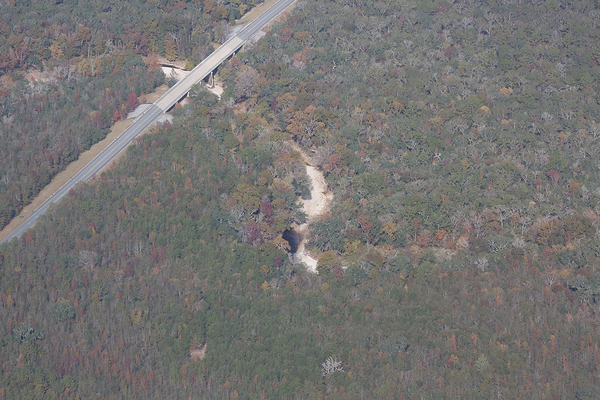
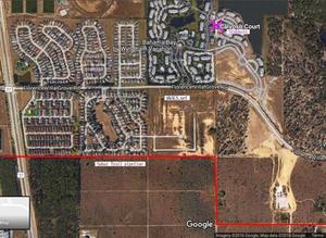
A major sinkhole developed today within about 2000 feet of Sabal Trail’s path in Osceola County, Florida. Rather like what we warned them about last year in WWALS v Sabal Trail & FDEP.
 Caitlin Doornbos, Orlando Sentinel, 9 Dec 2016,
Sinkhole displaces residents of condo complex west of Disney World,
Caitlin Doornbos, Orlando Sentinel, 9 Dec 2016,
Sinkhole displaces residents of condo complex west of Disney World,
Multiple families were displaced after a sinkhole developed in a gated condominium complex west of Disney’s Animal Kingdom on Friday, Osceola County officials said.
The sinkhole was first reported in Continue reading
Update 2016-12-08: Complaint filed with GA-EPD, USACE, FERC:
PDF.
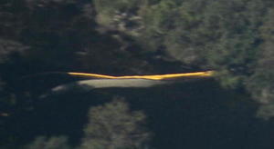
 We didn’t see any silt fences where Sabal Trail has red pipe laid out across Okapilco Creek and Little Creek,
north of Coffee Road, west of GA 333 in Brooks County, Georgia, between Barwick and Barney.
We didn’t see any silt fences where Sabal Trail has red pipe laid out across Okapilco Creek and Little Creek,
north of Coffee Road, west of GA 333 in Brooks County, Georgia, between Barwick and Barney.

Red pipe, Okapilco Creek Middle Bridge, Sabal Trail, 30.9174160, -83.5892520
 You won’t hear
this every day.
Thanks to Flint Riverkeeper Gordon Rogers for pointing to these Okefenokee Swamp hollers by Walter Parks.
You won’t hear
this every day.
Thanks to Flint Riverkeeper Gordon Rogers for pointing to these Okefenokee Swamp hollers by Walter Parks.
And don’t forget WWALS has an outing 10AM this Saturday December 10th at Georgia’s Stephen C. Foster State Park on the Suwannee River near Fargo, GA, to paddle into the Okefenokee Swamp. Continue reading
FOR IMMEDIATE RELEASE
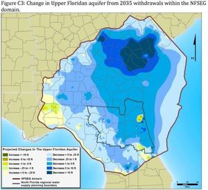
Jasper, Florida, November 6th 2016 — Better modeling and measurement of more water reuse and retention with fewer water withdrawals in both north Florida and south Georgia, WWALS Watershed Coalition (WWALS) recommended yesterday in comments (PDF) on the North Florida Regional Water Supply Plan (NFRWSP). WWALS also opposed the Falling Creek Aquifer Storage project and suggested a replacement, and recommended including threats to the FLoridan Aquifer and the Suwannee, Withlacoochee, and Alapaha Rivers such as pipelines and fracking.
 WWALS applauded water supply projects involving reuse or stormwater,
especially those in Jacksonvile and Gainesville, two of the sources of the
general problem of falling water levels in the Floridan Aquifer.
WWALS also applauded the plan to set minimum flow levels on the upper Suwannee River and WWALS expects to be involved with that.
WWALS applauded water supply projects involving reuse or stormwater,
especially those in Jacksonvile and Gainesville, two of the sources of the
general problem of falling water levels in the Floridan Aquifer.
WWALS also applauded the plan to set minimum flow levels on the upper Suwannee River and WWALS expects to be involved with that.
WWALS recommended expanding the original study area, which stopped at the Suwannee River on the west and the Georgia-Florida state line on the north. WWALS president John S. Quarterman explained,
“Our rivers don’t stop because there’s a state line on a map, and there are three second-magnitude springs on the Withlacoochee River in Georgia south of Valdosta, one of them with a more than 4,000-foot cave system, that aren’t taken into account in this draft plan.”
Quarterman elaborated on a much larger concern: Continue reading
Update 2016-12-08: Letter sent to VA529 board: PDF.
Do the parents and grandparents who bought Virginia529 funds as safe investments for future college know VA529 is the biggest mutual fund investor in risky investments Spectra Energy of Sabal Trail and Enbridge of the Dakota Access Pipeline? Maybe you’d like to point that out to Mary G. Morris, the Chief Executive Officer of Virginia529 College Savings Plan, the biggest mutual fund investor in both Spectra Energy and in Enbridge, which is buying Spectra.

There’s a handy VA529 contact form or you can call or write: Continue reading
Sabal Trail only barely misses the Withlacoochee River in Florida, even though it no longer crosses over into Madison County. And it’s the same Floridan Aquifer on both sides of the river.
Springs and pipeline, 30.4828540, -83.2577470: The red line is Sabal Trail in Hamilton County. In the foreground in Madison County is Madison Blue Spring on the Withlacoochee River, and the P is Pot Spring farther downstream. The N is Nestle; you’d think they’d care about potential damage to the aquifer from which they suck water.
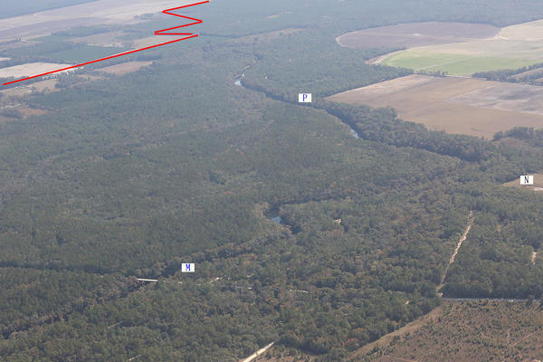
Withlacoochee River, pipeline, 30.4591650, -83.2224900: Close enough? Continue reading
Some national coverage! Now that the U.S. Army Corps of Engineers has backed off letting the Dakota Access Pipeline drill under the Missouri River in North Dakota because of concerns of local water users, the Corps, FERC, and FDEP should do the same: stop Sabal Trail from drilling under the Suwannee River.
 Larry Buhl, DeSmogBlog, 4 December 2016,
Critics Call $3 Billion Sabal Trail Pipeline
Florida’s Dakota Access Pipeline,
Larry Buhl, DeSmogBlog, 4 December 2016,
Critics Call $3 Billion Sabal Trail Pipeline
Florida’s Dakota Access Pipeline,
As opposition to the Dakota Access pipeline swells at home and abroad, another pipeline project at the other end of the U.S. is quietly being installed as fast as possible, critics say, displacing residents, threatening water supplies, and racking up alleged construction violations.
And most people in the region — even those in the pipeline’s path — haven’t even heard about it.
Sabal Trail Transmission, LLC, known as Sabal Trail, is using $3 billion of Florida Power and Light (FPL) ratepayer money to build a 515-mile pipeline to transport natural gas obtained via fracking from eastern Alabama to central Florida.
…
Activists Document Construction Violations
Continue reading
The Alapaha River is dry much of the year in most of its Florida run, because it goes underground upstream and comes back up in the Alapaha Rise, which is actually upstream on the Suwannee River from the Alapaha Confluence. The Cody Scarp causes this underground river phenomenon. See also the WWALS Alapaha River Water Trail.