Category Archives: Pipeline

Suwannee River HDD, Sabal Trail, SRSP, Withlacoochee River, Pilgrim’s Pride

Suwannee River HDD Sabal Trail, 30.4137540, -83.1615120 
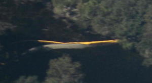
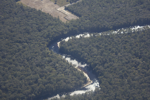
Sabal Trall will soon start drilling under the Suwannee River, and under Suwannee River State Park and the Falmouth Cathedral Cavern System next to Pilgrim’s Pride on US 90. 
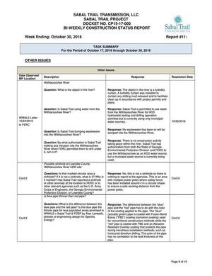
According to Trail’s November 4th 2016 biweekly report, clearing and pad completion should be done by about now, so they’re about to start horizontal directional drilling (HDD), like they’re already doing under the Santa Fe River in Florida and 
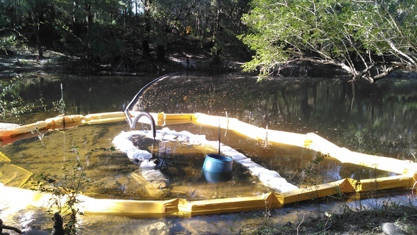
the Withlacoochee River in Georgia. At both of those rivers they’ve been seen in apparent violations. What will they do under the Suwannee River?

Pilgrims Pride, Sabal Trail, US 90, SRSP, Withlacoochee, Suwannee Rivers, 30.3872170, -83.1392640

Pilgrims Pride, Sabal Trail, US 90, SRSP, Withlacoochee, Suwannee Rivers,

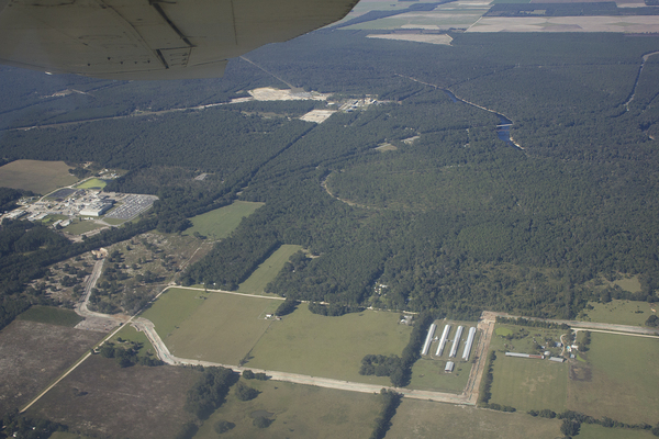
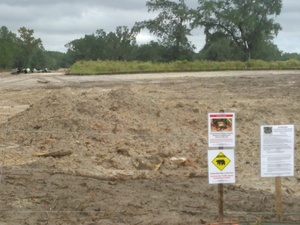
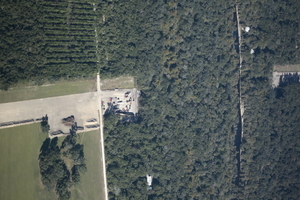
These pictures show how close Sabal Trail and the HDD sites are to the river, the park, the springs, and US 90. Continue reading

What is Sabal Trail sending into the WIthlacoochee River between Quitman and Valdosta, GA? WWALS PR 2016-11-09

Update 2016-11-14: GWC Dirty Dozen Press Conference at US 84 Bridge with tour of Sabal Trail HDD 2016-11-16

Update 2016-11-13:Sabal Trail still leaking drilling mud into the Withlacoochee River at US 84 in GA 2016-11-12

Update 2016-11-11: Sabal Trail leaked drilling mud up into the Withlacoochee River.

FOR IMMEDIATE RELEASE

Hahira, GA, November 9th 2016 — Sabal Trail appears to have contradicted itself in its recent responses to WWALS, perhaps admitting it may be dumping drilling mud into the Withlacoochee River, which would explain the picture below of a black pipe coming from Sabal Trail’s Brooks County HDD site into the river. WWALS had to wait two weeks just to get those non-answers, so WWALS now asks for a written response by email tomorrow. In addition, at least two Sabal Trail yards (a contractor yard in Moultrie, GA and a pipe yard near Lake City, FL) appear never to have been approved by FERC.

Dumping
About 2000 feet upstream (north) of the US 84 bridge. Many more pictures here.

“FERC granted permission in less than a week for Continue reading

Non-answers in Sabal Trail Biweekly Status Report 2016-11-04

If drilling mud may be released, how can this also be? “No wastewater has been or will be dumped into the Withlacoochee River.” Sabal Trail seems to have contradicted itself. Sabal Trail responses to WWALS questions And didn’t answer the permit questions from WWALS. Nonetheless all their responses are marked “Resolution Date: 10/30/2016”. Nope, not resolved, Sabal Trail. See new questions.

Sabal Trail also said (see the PDF) it was completing drilling under the Flint River, was drilling under the Ochlockonee and Withlacoochee Rivers in Georgia, had just started under the Santa Fe River, was doing clearing and pad preparation for the Chattahoochee and Suwannee Rivers, and hadn’t yet started anything at the Withlacoochee (south) River in Florida. Plus quite a few complaints and questions, including some from FERC, and some archaeological discoveries which Sabal Trail and FERC hid under “Privileged and Confidential information”.

The Sabal Trail responses labeled Continue reading

CY3-6 full less than a day after FERC approval: Sabal Trail Moultrie contractor yard 2016-10-22

Less than a day after FERC rubberstamped (or did it?) Sabal Trail’s request for a new contractor yard on the east side of Moultrie, Georgia, WWALS saw that yard already full of materials. Did Sabal Trail really move everything in that fast, or were those things already there, like the notorious Lake City, Florida pipe yard that never has gotten any formal FERC approval that we’ve seen?

Here’s what we saw from the Southwings flight for WWALS on Saturday October 22nd 2016:

CY3-6 area of Sabal Trail overview map

Compare with the overview map Sabal Trail filed with its request to FERC of Monday October 17th 2016: Continue reading

Waterkeeper Alliance asks Obama to halt DAPL

WWALS has been tying #NoDAPL to #NoSabalTrail for some time, because water protectors here continue to fight Sabal Trail for many of the same reasons as the Standing Rock Sioux fight the Dakota Access Pipeline, plus one of the DAPL pipeline companies, Enbridge, is buying Spectra Energy, the Sabal Trail pipeline company, and many of the same banks finance both.

Plus even FPL admits there’s no need for new electricity for Florida until 2024 at the earliest, which means there’s no need for Sabal Trail.

Waterkeeper Alliance, 3 November 2016, Waterkeeper Alliance Calls on President Obama to Halt the Dakota Access Pipeline and Uphold the Rights of Water Protectors, Continue reading

Crowdsourcing pictures of Sabal Trail path

Update 2016-11-29: Added to this google map: WWALS aerials of Gilchrist County, and Sabal Trail alignment maps localized by LAKE for Mitchell, Colquitt, Brooks, and Lowndes Counties, Georgia, and Hamilton, Suwannee, and Gilchrist Counties, Florida to just north of Bell, FL.

Update 2016-11-04: Now with Sabal Trail route digitized through Gilchrist, Alachua, and part of Levy Counties, plus part of the Citrus County line.

Signs, silt fences, backhoes in wetlands: you can log pictures on a map of anything going on at a Sabal Trail construction site from your mobile phone, tablet, or laptop. Already posted your pictures on the web? Link them into the map. Here’s how.

You’ve seen many pictures posted by WWALS, taken on the ground and in the air, and linked into a google map (which also has Sabal Trail’s alignment maps linked in).

Here’s another google map, to which more people can add pictures.

If you want to add pictures to this new crowdsourcing google map, you need to: Continue reading

Aerials: Suwannee, Ocholockonee, Withlacoochee, Santa Fe Rivers, Okapilco Creek, Sabal Trail Moultrie CY3-6 @ WWALS Southwings 2016-10-22

Update 2016-11-07: You can put your own pictures on a related google map.

Digging under I-10 with traffic on it, 30.3512070, -83.1606820 From the air what you can’t see from the ground: Sabal Trail through north Florida and south Georgia.

Driving down I-10, you wouldn’t know Sabal Trail was digging underneath you,g for example.

Digging under I-10 with traffic on it,

On Saturday October 22nd 2016, Southwings flew WWALS over more than 100 miles of the Sabal Trail route: Continue reading

Sabal Trail between SRSP and I-10 in Suwannee County, FL 2016-10-16

Signs and pipe, 30.3918 -83.152922 Does Sabal Trail think black bears can’t walk the short distance from 24th Street, Stagecoach Road, and US 90 to 199th Place? What about those fox squirrels and indigo snakes? Gopher tortoises are also more places than people might think.

And what about that sinkhole only about 200 feet from the pipeline at Pilgrim’s Pride on US 90? These two pictures were taken from the same place, looking in opposite directions:

w. to Sabal Trail, less than 200 feet from sinkhole, 30.3721680, -83.1550210 e. to huge sinkhole just s. of US 90 e. of Pilgrims Pride, 30.3720440, -83.1548290

Here are the pictures, from north to south. I actually started on Continue reading

US 129 HDD Santa Fe River Sabal Trail 2016-10-22

South to North HDD, 29.9122530, -82.8515280 Sabal Trail plans to start drilling here in the next few days. I count three houses within the blast radius just in this picture at the Santa Fe River just east of US 129 in Suwannee and Gilchrist Counties, Florida. See also Jim Tatum’s pictures of this Santa Fe River Sabal Trail HDD location from this flight. Continue reading

From the air: US 84 HDD Withlacoochee River Sabal Trail 2016-10-22

Update 2016-10-24: Questions filed with FERC in Docket CP15-17 as Accession Number 20161024-5049 and emailed to USACE and GA-EPD (PDF).

Extreme closeup yellow in Withlacoochee River, 30.7952780, -83.4524840 What is that yellow thing in the river, Sabal Trail? Is that a sinkhole you’ve marked at the Lowndes County HDD site? And does blue pipe mean thinner for rural areas like your executive from Houston told us in WWALS v Sabal Trail & FDEP?

FERC gave you permission to Continue reading