Tag Archives: Alapaha River

Alapaha River Wildlife Management Area

Update 2017-04-28: Sandhills and wildlife at Alapaha WMA
WWALS is gratified that people are contacting us about the WMA, but we’re just reporting on it, we do not run it.
Contact information for the Alapaha WMA:
Greg Nelms, Wildlife Biologist, Game Management, Wildlife Resources Division, GA-DNR
(229) 426-5267 | M: (404) 985-6424

Update 2016-10-20: WMA check-in hunt does not count towards Georgia bag limit.

Update 2016-10-18: Video of Deserter Lake in the Alapaha WMA and hunting dates and bag limits.

Halfway between Tifton and Ocilla on the Alapaha River in Irwin County, apparently announced only by a public hearing in July about hunting reglations: Line Map: Alapaha River WMA the new 7,000-acre Alapaha River Wildlife Management Area (WMA). There’s an information kiosk off of US 319. , with the sign-in kiosk and campground across the WMA: from Ocilla take US 319 S, left onto Hawthorn Ln, right onto Palm Rd, right onto Farm Rd.
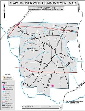
Update 2016-08-30: According to Greg Nelms, Wildlife Biologist, DNR, the main entrance will be off of US 319; there is already a WMA sign there. It’s not quite open yet; they’re still working on roads. A ribbon cutting is scheduled for September 30th. The first hunting season will be an archery hunt on October 1st; hunters can go in at noon the previous day to set up stands.

Here’s the announcement of the public hearing: GA DNR/Wildlife Resources Division/Game Management, 6 July 2016, Proposed Regulations for Alapaha River WMA; Public Hearing Scheduled,

The new regulations, probably adopted unchanged, and which seem to consist of dates and conditions for hunting seasons for various game animals, are online here.

Several maps are linked in for Continue reading

Anhinga Trek on the Georgia Southern Rivers Birding Trail

Sites in WWALS watersheds include Paradise Public Fishing Area (PFA) at the headwaters of our Withlacoochee River, Reed Bingham State Park on our Little River, Grand Bay Wildlife Management Area (WMA) upstream from our Alapaha River, and Stephen C. Foster State Park at the headwaters of our Suwannee River in the Okefenokee Swamp, all on the Anhinga Trek of the Southern Rivers Birding Trail.

You can buy a license for any of these parks or WMAs from the state, and you can also see anhingas and other fascinating wildlife on our water trails.

Or come along on upcoming WWALS outings: Continue reading

Suwannee River Outing tomorrow, plus Withlacoochee and Alapaha coming up

Don’t forget, 8AM tomorrow August 13th 2016, its a WWALS paddle outing from Roline to Cypress Creek on the iconic Suwannee River.

The water level is looking good.

Follow this link for directions, facebook event, meetup, etc.

If you can’t paddle tomorrow, WWALS holds monthly paddle outings, with the occasional on-land cleanup like next month:

For more outings and events as they are posted, see the WWALS calendar.

-jsq

You can join this fun and work by becoming a WWALS member today!

Rivers-Alive Cleanup at Berrien Beach Launch, Alapaha River 2016-09-10

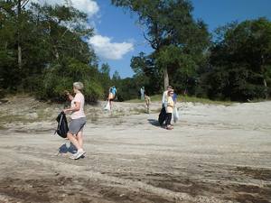
No boat needed! This Rivers-Alive Cleanup is on land, at GA 168, the launch for Berrien Beach on the Alapaha River. Bring gloves. Trash bags will be supplied. 300x221 Public access on north side of bridge, with cement strip boat ramp at higher water level but no facilities. Access road is unpaved and about 1/4 mile long. Nice sandy beach., in Berrien Beach at GA 168 on the Alapaha River, by Bret Wagenhorst, for

When: 4PM Saturday September 10th 2016

Where: Berrien Beach Launch, at GA 168, 31.159076, -83.045554

Directions: 12.9 miles east of Nashville, GA on GA 168; launch access road is on left (north) side of highway west of the river.

Duration: about 1.5 hours.

Events: facebook, meetup.

Responsible party: Bret Wagenhorst

This outing is Free! But we encourage you to join WWALS today Continue reading

Where to look for dye from Alapaha Dye test

Update 2023-05-01: Alapaha Swallets Dye Trace Project 2016-10-01.

Tom Greenhalgh dying the Dead River, Harley Means, and a drone Tom Greenhalgh started putting the dye in the Dead River Swallet about 11:06 this morning, with Harley Means observing in this picture, plus a drone also taking pictures. See below for where to look for the dye coming back up in the next few days. If you see it, please take a water sample for SRWMD. Continue reading

Dye test in Dead River Sink on Alapaha River

Update 2016-06-22: Dye test into the Dead River Sink: it came back up several days later and eighteen river miles south, in the Alapaha River Rise and Holton Bluff Spring, both on the Suwannee River.

The Alapaha River disappears underground in dry seasons, and nobody has ever known where it comes back up. Soon, we will know.

Green Publishing, 16 June 2016, Dye test held for river basins,

The Florida Geological Survey will be conducing a dye test for the Suwannee River Water Management District in the Upper Suwannee/Alapaha River basins later this month. They will introduce dye into the Dead River Swallet (swallets are sinkholes that capture flow) and a swallet that is located on privately owned land. They will also have sampling devices setup at Continue reading

Valdosta force main and new WWTP are online and working

The recent rains caused little wastewater overflow, according to Valdosta City Council Tim Carroll, who forwarded cryptic Valdosta press release yesterday and then explained on the telephone what it meant: Map the two biggest pieces of Valdosta’s wastewater and sewer fixes are operational already.

The press release referred to “the new force main” as if it were already in operation, yet nothing on Valdosta’s website says it is. So I called Tim Carroll and he confirmed that yes, the force main is online. Not only that, but 5 million gallons less water than usual for such rains entered the new Withlacoochee Wastewater Treatment Plant (WWTP).

Wait, does that mean the new, uphill, out-of-the-floodplain WWTP is also online? Yes, confirmed Carroll. And the less inflow was due to less INI.

What’s INI, I asked, ignorantly? Continue reading

We have a right to expect waterways and groundwater to be clean –Dennis J. Price

Another letter against Sabal Trail and for the rivers and the aquifer in the paper Suwannee Democrat, May 5th 2016.

In response to Jason Bashaw’s, Chairman of the Suwannee County Commission, article in the Suwannee Valley Times, I have this to say. Why is it that if people are concerned about the environment they live in, they are automatically placed into this environmental left category? Like many, many people in our surrounding counties, I hunt, fish, hike and paddle our local rivers. I use the environment as do we all.

I use the environment as do we all. So, for working and paying taxes all my life — as a Vietnam Veteran, as a person who chose to live in this rural part of Florida and raise his kid, as a person who is not now nor ever will be wealthy — I count our public lands, our woods and rivers as a reward for doing the right thing. I do not mind my tax dollars going towards public lands. Mr. Bashaw uses the environmental left in a derogatory manner as a means of denigrating them, and he is including me in it and I resent it. I resent it for my friend’s in WWALS and others who show concern for the pipeline route. I have not met an environmental lefty among them.

WWALS is, Continue reading

Drowning at Pafford’s Landing on the Alapaha River 2016-05-07

One version of the Saturday drowning on the Alapaha River near Lakeland is being carried all over the country, Lanier Parks, Inc. Parcel 030 0038B from Richmond to Texas, and there is another version.

Terry Richards, valdosta Daily Times, 9 May 2016, UPDATE: Father dies saving Lanier child from drowning,

A small child wandered away from a group of adults and into the Alapaha River at Pafford’s Landing, he said. When the father noticed what had happened he jumped in, swam to his daughter who was struggling to keep her head above water and held her up until someone took her from him, Norton said. The father never resurfaced.

Pafford’s Landing is at Continue reading

Alapaha River Boat Ramp

These are the maps Lowndes County Engineer Mike Fletcher presented at the Naylor Town Hall 2016-04-14. Roads and parking lot Bret Huntley asked him to send them, and he did.

These have more detail than Continue reading