Update 2025-10-07: Public Hearing, Bradford Road subdivision @ Berrien Planning Commission 2025-10-16.
I handed this letter to the Berrien Planning Commissioners and the Zoning Administrator before I spoke to them at the recent Public Hearing. They tabled this item for another month, awaiting more documents from the applicant, Cole Livingston, for his proposal to subdivide for ten houses in an agricultural character area on Bradford and Strawder Roads and Old Valdosta Highway, in Berrien County, Georgia, draining to Gin Branch Creek and the Withlacoochee River.
![[Water issues, Bradford Road subdividing, WWALS 2025-09-18, to Berrien Planning Commission]](https://www.wwals.net/pictures/2025-09-18--wwals-berrien-co-bradford-road/many.jpg)
Water issues, Bradford Road subdividing, WWALS 2025-09-18, to Berrien Planning Commission
September 18, 2025
To: Teresa Willis
Berrien County Zoning Administrator
229-686-2149
twillis@berriencountyga.gov
201 N. Davis Street Room 122
Nashville GA 31639Re: Subdividing M&P 061-14-000, 061-16-002, Old Valdosta Rd. & Bradford Rd.
Dear Berrien County Zoning Administrator and Planning Commission,
Please recommend denial of the proposed subdividing, because:
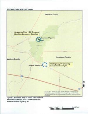
- House lots would produce more runoff, which would run onto neighboring properties, as attested by several neighbors at the previous Public Hearing on August 21, 2025. See attached LIDAR map and attached wetland and flood zone map.
- Runoff would carry trash and other contamination into Gin Branch Creek that runs north across Bradford Road and west into the Withlacoochee River. See attached map of Gin Branch Creek.
- Under Bradford Road and along Gin Branch Creek is an aquifer recharge zone, into the groundwater from which we all drink. We do not need to risk more contaminants possibly getting into that. See attached aquifer recharge map.
- Increased traffic and runoff would erode Bradford and Strawder Roads, requiring more work by the county to fix them.
- The houses would not be accessory to farm operations as in the Berrien County Comprehensive Plan Strategy for an Agriculture Character Area, which says: Continue reading
![[10.7feet]](https://wwals.net/pictures/2019-10-21--fim/10.7feet.jpg)
![[Prof. Don Thieme & Can Denizman, 13:30:33, 30.8515417, -83.3452859]](https://www.wwals.net/pictures/2019-11-26--vsu-geology-land-between-the-rivers/20191126_133032.jpg)
![[Donald M. Thieme, Associate Professor, Geology, VSU]](https://www.wwals.net/pictures/2019-10-31--wwals-gosp-troupville-river-camp/big/Thieme_12_5_2019-0001.jpg)