Tag Archives: Ray City

AGL pipeline explosion settlement deferred again by GA-PSC for state-wide safety: needs to add LNG 2019-09-19

For more time to examine where gas detectors are needed throughout the state, GA-PSC has again deferred voting on the AGL settlement. As Commissioner Jason Shaw said at the first deferral Tuesday, they want to “make sure that all across the state we can make sure that this type of equipment…” is available.

Plus GA-PSC should take a hard look at AGL subsidiary Pivotal LNG’s Liquid Natural Gas (LNG) liquefaction facilities and truck and train routes from them to Jacksonville, Florida, especially since the Federal Energy Regulatory Commission (FERC) has shirked its oversight duties for inland LNG facilities.

AGL pipeline map, Georgia
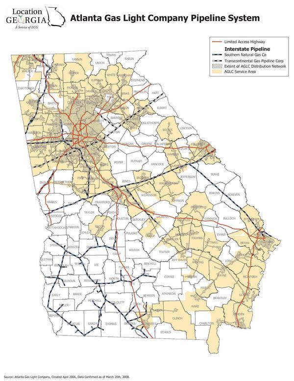
Georgia, AGL Pipeline Map, in Homerville, GA pipeline explosion, by John S. Quarterman, 17 August 2018

AGL has pipelines all over the state of Georgia. I don’t know any reason to believe any of them are any safer than the one that goes from my property in Lowndes County to Homerville in Clinch County (and to Moody Air Force Base, to parts of Valdosta, to Ray City in Berrien County, and to Lakeland in Lanier County).

The map above is the newest I could find online. It was last updated in 2008, more than a decade ago. No doubt AGL can provide the PSC with more current mapping data. Maybe the PSC could require AGL to provide an updated map to the public.

The Public Map Viewer by the Pipeline and Hazardous Safety Administration (PHMSA) is no help: it does not include AGL’s distribution pipelines such as the one to Homerville.

PHMSA was sufficiently concerned about the Homerville Coffee Corner explosion that it wrote on AGL’s report to PHMSA: Continue reading

Make sure we have an adequate amount for departments all across the state in AGL settlement –GA-PSC Commissioner Jason Shaw 2019-09-17

Deferred: the AGL gas explosion settlement agreement, to be sure enough county fire departments are covered, and there is “an adequate amount” to do that. Maybe now Lowndes County and Berrien County and Ray City can be added to the list of departments to get gas detection equipment. No doubt AGL will be happy to provide more funds to accomplish this prevention of explosions such as happened last fall in Homerville, GA.

[Commissioner Jason Shaw]
Commissioner Jason Shaw

Thanks to Commissioner Jason Shaw for speaking up for the people of the state of Georgia at this morning’s GA-PSC meeting.

I would like to hold item R1. I think there are some questions.

Continue reading

Ockolocoochee, Little River 1889-01-29

Update 2023-12-28: Revised version..

Who knows the Ockolocoochee River? No, not the Ochlockonee River; that’s a bit to the west. You do know the Ockolocoochee River as the Little River, of the Withlacoochee, of the Suwannee. Here is news from 1889 that also includes the boat that didn’t survive from Troupville to Ellaville, which was apparently not a paddlewheel steamer.


Irwin County, 1885a, GeorgiaInfo, Rand McNally Map of Georgia, 1885

Atlanta Constitution, January 29, 1889, Pg 12., quoted in Ray City History Blog, 18 October 2010, More About Troupville, GA and the Withlacoochee River,

THE WITHLACOOCHEE RIVER.

VALDOSTA, Ga., January 19. -[Special.]- Away up near the northern limit of the great wiregrass section there is a big cypress swamp. They call them bays there. From this bay emerges Continue reading

Old Coffee Road, Georgia

The Google map of locations on Old Coffee Road was used by many of the early settlers of south central Georgia, including in the watersheds of the Willacoochee, Alapaha, Withlacoochee, and Little Rivers and Okapilco Creek. It crossed all those and other waterways by ford or private ferry: there were no bridges back then.

Old Coffee Road map, WWALS.net
Follow this link for the interactive google map.

The Georgia Historical Commission erected markers at half a dozen locations in the 1950s and 1960, reading: Continue reading

Ray’s Mill Pond, 2016-04-02

See you 9AM tomorrow morning April 3rd for the WWALS Outing at the 3,500 acre Ray’s Mill Pond, View from boatramp which is open for boating 24/7; just put a dollar in the box. In the evenings Monday thru Thursday, don’t park your boat on the pavement because the restaurant is open then, and it’s very popular, but no worries on a Sunday morning.

You can join this fun and work by becoming a WWALS member today!

-jsq

You can join this fun and work by becoming a WWALS member today!

View from boatramp
View from boatramp

Deposit .00 Launch Fee Here

Launch Fee .00
Launch Fee .00

No Boat Trailers on Paved Lot Thursday Thru Saturday 4PM til 10PM

Busy restaurant parking lot

Cat Creek flooding
Cat Creek flooding

Rays Mill Pond spillway

View from walkway
View from walkway