
Commissioners from counties on both sides of the Suwannee River saw the sinkholes and big oaks and pines directly above and near where
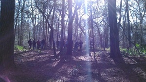 Sabal Trail proposes to bore under Suwannee River State Park and the River,
led by WWALS board member and Hamilton County resident Chris Mericle,
assisted by Debra Johnson of SpectraBusters, Merrillee Malwitz-Jipson of Our Santa Fe River (OSFR), and others from as far away as south Florida.
All but one of the Suwannee County Commissioners were there, and he had a good excuse.
They also saw Falmouth Spring, which is part of a cave system which Sabal Trail claims is 100 feet deep. Both county commissions meet Tuesday March 1st; see below for details.
WWALS videos
Sabal Trail proposes to bore under Suwannee River State Park and the River,
led by WWALS board member and Hamilton County resident Chris Mericle,
assisted by Debra Johnson of SpectraBusters, Merrillee Malwitz-Jipson of Our Santa Fe River (OSFR), and others from as far away as south Florida.
All but one of the Suwannee County Commissioners were there, and he had a good excuse.
They also saw Falmouth Spring, which is part of a cave system which Sabal Trail claims is 100 feet deep. Both county commissions meet Tuesday March 1st; see below for details.
WWALS videos to come now posted.
You can see Continue reading
Tag Archives: river
WWALS Watersheds google map
Update 2020-01-25: Superseded by WWALS Suwannee River Basin Map and All Landings in the Suwannee River Basin, now that Suwannee Riverkeeper territory includes the entire Basin plus Estuary, since Waterkeeper Alliance agreed to add the Ichetucknee and Santa Fe Rivers on September 26, 2019.
Update 2017-10-30:
River flowlines.
Update 2017-10-08:
Better colors plus a Suwannee River Basin map.
Update 2017-04-13: Since December 2016 WWALS Watersheds have included the Lower Suwannee River HUC 03110205
and the Suwannee River Estuary, approved by Waterkeeper Alliance the same time as the license for Suwannee RIVERKEEPER®.


Click on this link for an interactive google map of WWALS watersheds.
The images you see here are static screenshots of that google map. Follow the link above for the actual google map.
The watershed outlines are from Continue reading
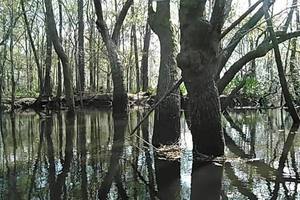
Pictures: Long Alapaha Outing, GA 135 to GA 168 2016-02-20
You never know on our blackwater rivers in south Georgia and north Florida. The danger! The thrill of the rapids!
 OK, it was actually more like paddling on a lake with a current.
The hardest part was when the wind picked up against us a few times.
Sometimes we heard what sounded like rapids, but it was just flotsam lodged against oak trees.
OK, it was actually more like paddling on a lake with a current.
The hardest part was when the wind picked up against us a few times.
Sometimes we heard what sounded like rapids, but it was just flotsam lodged against oak trees.
But that’s the point: you really never know until you’re on the water, and on a trip like this with no good takeout until the end of the 18.25 miles, being prepared it much better than not.
The current did make for Continue reading
Expert paddlers get ready for Long Alapaha River Paddle, GA 135 to GA 168 (Berrien Beach) 2016-02-20
Update 2016-02-21: Actually it took 6 hours. Here are some pictures.
The water is high and fast, so expert paddlers only, arrive by 8AM at GA 135 (Atkinson County side), and be ready so we can shuttle quickly and get on the Alapaha River as soon as possible.
 It’s a long way and we need to be off the river before dark.
Berrien County Sheriff, game warden, and emergency response have all been advised of this trip, but expert paddlers only, please.
As always, bring personal flotation devices, warm layers of clothes, drinking water, food, and a change of dry clothes.
There is no good place to take out before the end point, so be prepared to paddle all day.
It’s a long way and we need to be off the river before dark.
Berrien County Sheriff, game warden, and emergency response have all been advised of this trip, but expert paddlers only, please.
As always, bring personal flotation devices, warm layers of clothes, drinking water, food, and a change of dry clothes.
There is no good place to take out before the end point, so be prepared to paddle all day.
The USGS Gauge at Alapaha, GA shows 9.41 feet this morning, which is a good level. The Statenville gauge shows 17.32, which while well below flood level is also well above our usual recommended high of 9 feet. That Statenville gauge is quite a few river miles (56 miles) below our takeout point at GA 168, so the main bulk of rainfall in the river has apparently already moved downstream. But the water is very high and very fast. You will come up on any deadfalls or overhanging limbs quite quickly. Expert paddlers only. There are many other outings and events coming up that are much better suited for other paddlers.

Continuing our exploration of the entire
Alapaha River Water Trail,
 we’re into the longer stretches, including this one.
When: 8AM Saturday 20 February 2016
Put In: GA 135, MILE 106.5, Atkinson County side, 2.8 miles south of Willacoochee, GA, Atkinson County.
Take Out: GA 168 (Berrien Beach), MILE 88.24, N side of GA 168, west side of Alapaha River; float downstream under the bridge to the sand beaches, Berrien County
Duration: 18.25 miles. This paddle could take as long as 9-10 hrs.
Shuttle: Probably more than 30 minutes due to distance.
End time: Around 6PM. Yes, really all day.
Responsible party: Chris Mericle
This outing is Free! But we encourage you to join WWALS today to support our fun outings and important work: https://wwals.net/donations/. Continue reading
Workshop at VSU, Outings, Movie, and Hike to the Suwannee River –WWALS to Lowndes County Commissioners
Following up on
the invitation I gave them in person last week,
 I sent this to the Lowndes County Commissioners just now,
addressed to
all five voting Commissioners, the Chairman, and the County Clerk:
I sent this to the Lowndes County Commissioners just now,
addressed to
all five voting Commissioners, the Chairman, and the County Clerk:
Subject: Workshop at VSU, Outings, Movie, and Hike to the Suwannee River
Dear Commissioners,
Thanks again for the continued work on the Alapaha Boat Ramp, which will contribute to the quality of life recommended in the Comprehensive Plan.
As I mentioned at your Regular Session last week, you are invited to several WWALS events coming up soon, especially this one, which requires no boats: Continue reading
Suwannee County Commission voted to oppose fracking 2016-02-16
WWALS member Debra Johnson reported last night on SpectraBusters, Suwannee County Opposes Fracking and Revocation of Home Rule,
Joining Forty-one different cities and 27 counties in Florida that have voted to ban fracking or have expressed their opposition to it since January 2015, Suwannee County BOCC approved three identical fracking opposition letters to Governor Scott, Pro-fracking Bill Sponsors Senator Richter (SB 318) and House Representative Rodrigues (HB 191) tonight. These bills also contain language that would eliminate Home Rule for local governments concerning fracking.
Chairman Jason Bashaw stated that the board was in agreement that Continue reading
Sewage into Two Mile Branch towards the Withlacoochee River 2016-02-15
I wonder what this “debris” was? And the rags? Anyway, Valdosta has fixed another sanitary sewage spill. Probably if you stay out of the water around 2500 Bemiss Road (south of Northside Drive) you’ll be OK. But you may also want to know where Two Mile Branch goes downstream, and as usual Valdosta didn’t tell us.
 As we recall from Valdosta’s last episode of multiple wastewater spills earlier this month,
Two Mile Branch runs into Sugar Creek which goes into the Withlacoochee River,
and eventually into the Suwannee River and the Gulf of Mexico.
Don’t be surprised if you see a Florida Department of Health advisory
like the one earlier this month. Continue reading
As we recall from Valdosta’s last episode of multiple wastewater spills earlier this month,
Two Mile Branch runs into Sugar Creek which goes into the Withlacoochee River,
and eventually into the Suwannee River and the Gulf of Mexico.
Don’t be surprised if you see a Florida Department of Health advisory
like the one earlier this month. Continue reading
Hutchinson Mill Creek at Withlacoochee River, GA 122
Deadfalls on this creek,
backing up flood waters onto Skipper Bridge Road forcing a bridge to close in 2009,
 were one reason for the formation of WWALS.
Here are some pictures and a very brief movie.
were one reason for the formation of WWALS.
Here are some pictures and a very brief movie.
In a typical day for a Waterkeeper®, starting slow after a road trip to Atlanta the previous day with several Riverkeepers and other environmental organizations, I was preparing for the movie in Live Oak Friday evening when I got a message from Noelani Mathews wanting an interview about the pipeline movie. As I threw a kayak in the truck, the Yellow Dog hopped in, and Continue reading
Workshop at VSU: Withlacoochee and Little River Water Trail 2016-02-27
FOR IMMEDIATE RELEASE
Student logo contest winners, art show and silent auction, plus paddling, history, archaeology, and hydrology of the Little and Withlacoochee Rivers, WWALS Workshop at VSU 2016-02-27
With two dozen access points to these wild and scenic rivers that converge just outside Valdosta, an online map, and multiple outings coming up, the Withlacoochee and Little River Water Trail is coming along nicely, and its Committee is proud to announce a Workshop at VSU, 1:30 PM Saturday February 27th, 2016 at the University Center Theater at Valdosta State University.
What: Withlacoochee and Little River Water Trail Workshop
 When: 1:30 PM-4:30PM
Saturday, February 27th, 2016
Where: UC Theater,
University Center
Valdosta State University
1215 N. Patterson St.,
Valdosta, GA 31698
“Parts of these rivers are really wild!” said Continue reading
Online movie: At What Cost? Pipelines, Pollution and Eminent Domain in the Rural South
If you missed it in Live Oak last night, or in one of the previous premieres along the Georgia coast,
you can see the movie online:
 At What Cost? Pipelines, Pollution and Eminent Domain in the Rural South,
by Mark Albertin.
And yes, he’s happy for it to be shown elsewhere; just ask.
At What Cost? Pipelines, Pollution and Eminent Domain in the Rural South,
by Mark Albertin.
And yes, he’s happy for it to be shown elsewhere; just ask.
Thanks to Push Back the Pipeline for getting this movie made about Kinder Morgan’s proposed petroleum products pipeline from South Carolina across the Georgia coast to Jacksonville, Florida. Special thanks to Eileen, Lori, and Debra and the Woman’s Club of Live Oak for the movie showing last night, and to SpectraBusters, Our Santa Fe River, and Gulf Restoration Network for helping promote it. Don’t forget the hike to the Suwannee River Sabal Trail crossing 8:15 AM Thursday 28 February 2016 with Suwannee and Hamilton County Commissioners.
Most of the issues are the same for the invading Sabal Trail fracked methane pipeline which Continue reading