Update 2016-11-22:
-
Derrek Vaughn, Valdosta Daily Times, 17 November 2016,
WWALS Watershed Coalition hold demonstration (WWALS blog post),
-
Georgia Water Coalition, Waterkeeper Alliance, 17 November 2016,
“Dirty Dozen” Calls Out Most Threatened Waters in Georgia,
-
Bruce Ritchie, Politico, 17 November 2016,
Sabal Trail spill, protests across U.S. spur debate over natural gas pipeline in Florida,
-
 Ashlyn Becton, WALB, 16 November 2016,
Environmentalist raise awareness about Sabal Trail Pipeline (WWALS blog post),
Ashlyn Becton, WALB, 16 November 2016,
Environmentalist raise awareness about Sabal Trail Pipeline (WWALS blog post),
-
Nick Evans, WUSF, 14 November 2016,
Drilling Mud Leak In South Georgia Raises New Sabal Trail Pipeline Concerns
(WWALS blog post)
-
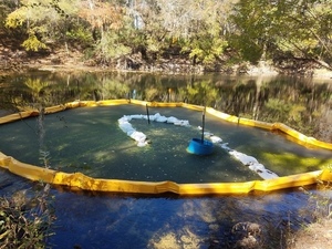
Steve Patterson, Jacksonville.com, 14 November 2016,
Gas pipeline project headed to Suwannee River leaks into Georgia waterway; sparks environmental worries (WWALS PR),
FOR IMMEDIATE RELEASE
 Hahira GA, November 14th 2016 (updated with directions and detail Nov 15th) —
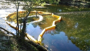
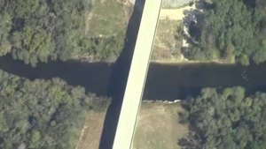
WWALS is holding an in-person press conference at the US 84 Withlacoochee River bridge to hear and participate in the announcement Wednesday morning of the Georgia Water Coalition (GWC) Dirty Dozen 2016: a dozen of the worst threats to Georgia’s waters.
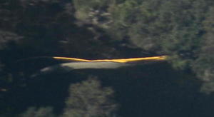
WWALS will then offer a hike up the riverside to the Sabal Trail pipeline crossing location, where Sabal Trail leaked drilling mud leak up into the river.
Hahira GA, November 14th 2016 (updated with directions and detail Nov 15th) —
WWALS is holding an in-person press conference at the US 84 Withlacoochee River bridge to hear and participate in the announcement Wednesday morning of the Georgia Water Coalition (GWC) Dirty Dozen 2016: a dozen of the worst threats to Georgia’s waters.
WWALS will then offer a hike up the riverside to the Sabal Trail pipeline crossing location, where Sabal Trail leaked drilling mud leak up into the river.
Please arrive by 9:30 to be ready for the GWC teleconference at 10AM.
On the phone call, details of the Dirty Dozen will be announced, with WWALS members assisting for one of them, and another also directly relevant to WWALS watersheds.
After the phone call,
people from Florida and Georgia will have an opportunity to speak, because the Withlacoochee flows downstream into Florida, where Sabal Trail also plans to drill under the Suwannee River, as well as the Santa Fe, where 14 people got arrested recently protecting, and the other Withlacoochee (south) River.
Let’s see a little cross-state-line solidarity against this unnecessary, destructive, and hazardous fracked methane pipeline boondoggle.
Call your local press before you come, and bring signs.
When: 9:30 AM Wednesday November 16th 2016
Where: US 84 bridge, east side, between Quitman and Valdosta, GA, 30.793747, -83.450167
It’s in the median of a busy highway, so be careful.
 What:
Press Conference for Georgia Water Coalition Dirty Dozen,
with hike up the river.
What:
Press Conference for Georgia Water Coalition Dirty Dozen,
with hike up the river.
It’s a rough hike, so come prepared with sturdy shoes and clothes you don’t mind getting dirty.
Or just participate at the bridge. Bring signs if you’ve got them, or make them on the spot.
This is a completely peaceful nonviolent first-amendment press conference.
Event: facebook
Directions: from Live Oak or Gainesville, FL or farther south, or from Albany, Tifton, or Macon, GA or farther north, take I-75 Continue reading →

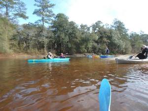 In January the water should be up like a year ago at this three-hour tour of the idyllic Little River between Brooks County and Cook and Lowndes Counties, Georgia.
There should be no need to drag boats, like there was in July.
In January the water should be up like a year ago at this three-hour tour of the idyllic Little River between Brooks County and Cook and Lowndes Counties, Georgia.
There should be no need to drag boats, like there was in July.


![[STA. 11870+00 TO STA. 11923+00, (UT OKAPILCO CREEK), 11881+44 CL SPAIN ROAD, 11871+70 CL GOLDING ROAD, BROOKS COUNTY, GEORGIA]](https://www.l-a-k-e.org/govt/ferc/2016-04-07--stt-supp/small/20160407-5081-31369074-0012.jpg)