
A fine full moon paddle on Banks Lake, plus Jupiter and a gator.
Tag Archives: swamp
![[Moon paddlers]](https://www.wwals.net/pictures/2019-07-16--banks-lake-moon/20190716_205647.jpg)
Charlton County, GA, BOCC 2019-07-18
Three people came up from Baker County, Florida, to get another copy of the mine application from Twin Pines Minerals (it matches the earlier copy) and then had to leave early. Emily Jones of Georgia Public Broadcasting (GPB) came from Savannah. Suwannee Riverkeeper (I) asked the Charlton County Commissioners to consider asking the U.S. Army Corps of Engineers to extend the application comment date. The Chair of St. Mary’s Riverkeeper spoke. The miners’ lobbyist sat silent.
![[Attorney?, County Administrator Hampton Raulerson, Absent Jesse Crews (3), Vice Chair Alphya Benefield (1), Chair James E. Everett (2), , Drew Jones (4), Luke Gowen (5), County Clerk Jenifer Nobles, Finance Coordinator Rebecca Harden]](https://www.wwals.net/pictures/2019-07-18--charlton-bocc/20190718_175920.jpg)
Thanks for hospitality to Attorney?, County Administrator Hampton Raulerson, Absent Jesse Crews (3), Vice Chair Alphya Benefield (1), Chair James E. Everett (2), , Drew Jones (4), Luke Gowen (5), County Clerk Jenifer Nobles, Finance Coordinator Rebecca Harden.
Since we learned that Twin Pines Minerals still has a hydrogelogical study in process with some unknown completion date, the thirty-day extension GPB announced the next day does not seem adequate, since a key study is missing. Remember to comment on the Corps’ and GA DNR dockets, and see below for the dates, times, and locations of upcoming meetings in Charlton County.
There was nothing on the agenda about the mine, so everything about it was in Continue reading
Deadline Extended to September 14 12 on mining proposal near Okefenokee NWR 2019-07-19
Update 2019-07-22: Corrected headline to match extension date in GPB story. See also Charlton County, GA, BOCC 2019-07-18.
I asked the Charlton County Commission just yesterday to ask the Corps for an extension, and numerous other people and organizations have done so. The Corps has already responded.
Emily Jones, Georgia Public Broadcasting, 19 July 2019, Army Corps Extends Comment Deadline On Mining Near Okefenokee,
The Army Corps of Engineers is extending the deadline for public comments on a proposal to mine for minerals near the Okefenokee National Wildlife Refuge.
The new deadline is September 12, an additional 30 days from the original deadline of August 13.
Environmental groups were calling for the deadline extension.
Since there’s nothing on the Corps’ Public Notices website about that, I asked her how she knew. She said Senior USACE Public Affairs Officer Billy Birdwell, 912-652-5014. So I called him.

Complete permit application, Twin Pines Minerals 2019-07-17
The complete 565-page permit application by Twin Pines Minerals, SAS-2018-00554, is now on the WWALS website.
News about it is all over North America, with more coming out daily.
You can go ahead and send in comments to the Army Corps of Engineers or to the Georgia Department of Natural Resources.
![[Twin-Pines-Individual-Permit-Application--complete-0006]](https://www.wwals.net/pictures/2019-07-17--tpm-permit/Twin-Pines-Individual-Permit-Application--complete-0006.jpg)
Twin-Pines-Individual-Permit-Application–complete-0006
You can retrieve the complete application from Continue reading
GPB on mining proposal near Okefenokee NWR 2019-07-15
My vegetable buyer from St. Mary’s, GA, said “I heard you on the radio this morning.” Notice the map Georgia Public Broadcasting posted says “Phase I” in U.S Army Corps of Engineers Application SAS-2018-00554. The company actually owns land northwards all the way up next to the swamp.
![[Phase I location Map]](https://www.wwals.net/pictures/2019-07-12--tpm-usace/SAS-2018-00554-Charlton-0712-SP-HAR-0007.jpg)
Emily Jones, GPB Radio News, 15 July 2019, Mining Proposed Near Okefenokee National Wildlife Refuge,
An Alabama company wants to mine for heavy minerals near the Okefenokee National Wildlife Refuge in southeast Georgia.
The proposal from Twin Pines Minerals called for Continue reading
Titanium mine near Okefenokee NWR 2019-07-12
Update 2019-07-18: The complete application is now on the WWALS website; you can comment now.
Friday, July 12, 2019, the U.S. Army Corps of Engineers published a Public Notice for Application SAS-2018-00554 for a titanium mine southeast of the Okefenokee National Wildlife Refuge (NWR). Thursday I attended a meeting at the Okefenokee NWR near Folkston about that, and I met with agents of the miners back in April. The application is about the little purple area on this map they showed us at the end of April:
![[Context]](https://www.wwals.net/pictures/2019-07-12--tpm-usace/20190430_141313.jpg)
But that’s not the whole story; see below. Today this mine proposal is on the agenda for the WWALS board meeting.
Here are some things the application doesn’t tell you: Continue reading
Defeat Suncoast Connector 2019-04-05
Please call your Florida state legislators to ask them to oppose a toll expressway across the Suwannee River, and maybe even across the Santa Fe or Ichetucknee Rivers. Instead, let’s do Amtrak passenger trains for better transportation and solar power for jobs and lower energy prices.
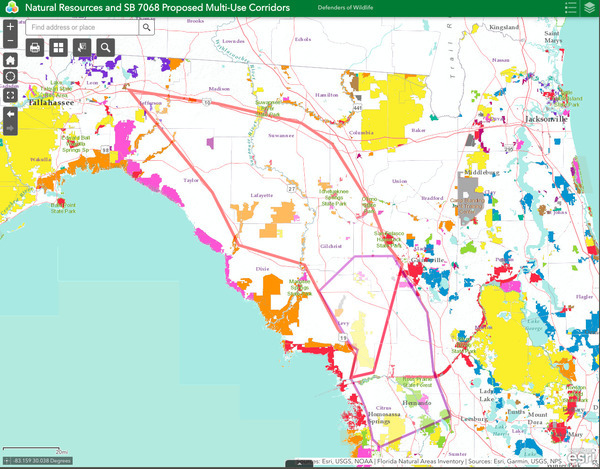
Suncoast Connector, Defenders of Wildlife
This boondoogle would come up from Citrus County to Jefferson County. That’s all the bills (SB 7068 or HB 7113) say about the route.
Defenders of Wildlife has a corridor map that shows Suncoast Connector coming from Crystal River in Citrus County, through Gilchrist and maybe Alachua Counties, possibly crossing the Santa Fe River into Columbia County and the Ichetucknee River into Suwannee County. It would have to cross the Suwannee River somewhere, maybe into Dixie or Lafayette or even Madison County, heading on through Taylor County to Monticello in Jefferson County.
Here’s a better way to improve transportation in the Suwannee River Basin: revive Amtrak through Madison and Lake City. The tracks are already there, so Continue reading
Testing for firefighting chemicals in wells and waterways 2019-01-18
Those firefighting chemicals that leaked from Moody Air Force Base are on the front page of the Valdosta Daily Times today:
Moody recommends private well owners contact their county representatives for information on testing personal wells.
Paige Dukes, Lowndes County clerk and public information officer, said this is an opportunity for county residents such as Tann to have their water tested. Not only for PFAS but for any other contaminants that might be there.
Indeed, and Lowndes County operates the Moody AFB wastewater treatment plant that spilled into Beatty Branch and Cat Creek. So it’s an opportunity for Lowndes County to help organize testing for these per- and polyfluorinated alkyl substances (PFASs), because testing for them isn’t nearly as simple or inexpensive as testing for other contaminants.
![[Suwannee Riverkeeper John S. Quarterman, nearby resident Debra Tann, VDT reporter Thomas Lynn and photographer Derrek Vaughn, at Beatty Branch, January 7, 2019. Photo: John S. Quarterman for WWALS.]](https://www.wwals.net/pictures/2019-01-18--moody-pfas-vdt/20190107_163624.jpg)
Suwannee Riverkeeper John S. Quarterman,
nearby resident Debra Tann, VDT reporter Thomas Lynn and photographer Derrek Vaughn, at Beatty Branch, January 7, 2019. Photo: John S. Quarterman for WWALS.
Debra Tann and I were back at Beatty Branch on January 7, 2019, this time with the VDT, about the firefighting chemical issue that was in the Atlanta Journal-Constitution the first week of January. This time it was for local reporters. Moody neighbor wants water tested, Continue reading
AJC at Moody AFB about groundwater contamination 2018-12-07
A month ago at Beatty Branch:
“Everything in this area depends on groundwater,” said John Quarterman, the Suwannee Riverkeeper in Lowndes County, where Moody is located. “I’m not saying that Moody necessarily did make enough contamination to be a problem, but I can’t tell from this report, and I don’t think it’s our responsibility to determine that they didn’t.”
![[Photographer Hyosub Shin and Reporter Meris Lutz]](https://www.wwals.net/pictures/2018-12-07--ajc-moody-afb/20181207_125050.jpg)
Photographer Hyosub Shin and Reporter Meris Lutz,
The Atlanta Journal-Constitution,
online today and in Sunday’s Atlanta paper newspaper,
Contaminated groundwater, a toxic legacy of Georgia’s air bases,
3 January 2019.
Moody Air Force Base tested their own wells, and found them clean. Which is good, but
![[Figure 2 AFFF Area Locations]](https://www.wwals.net/pictures/2018-12-07--ajc-moody-afb/Moody-site-inspect-PFOA-PFAS-0081.jpg)
Figure 2 AFFF Area Locations
PDF
their wells are much deeper than the wells the rest of us use in the country around here. Moody did not test any of those wells; Continue reading
Rivers bigger and more important that previously thought 2018-06-28
Rivers and streams cover more of the earth’s surface than previously thought, and likely interchange more CO2 and other gases with the atmosphere than previously thought. WWALS Science Committee Chair Tom Potter found this paper.
George H. Allen and Tamlin M. Pavelsky, Science, 28 Jun 2018, DOI: 10.1126/science.aat0636 Global extent of rivers and streams,
Abstract
The turbulent surfaces of rivers and streams are natural hotspots of biogeochemical exchange with the atmosphere. At the global scale, the total river-atmosphere flux of trace gasses such as CO2 depends on the proportion of Earth’s surface that is covered by the fluvial network, yet the total surface area of rivers and streams is poorly constrained. We used a global database of planform river hydromorphology and a statistical approach to show that global river and stream surface area at mean annual discharge is 773,000 ± 79,000 km2 (0.58 ± 0.06%) of Earth’s non-glaciated land surface, an area 44 ± 15% larger than previous spatial estimates. We found that rivers and streams likely play a greater role in controlling land-atmosphere fluxes than currently represented in global carbon budgets.
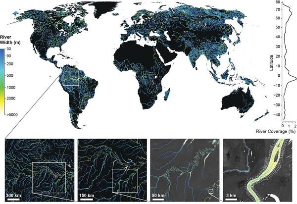
Fig. 1. The Global River Widths from Landsat (GRWL) Database
contains more than 58 million measurements of planform river
geometry. The line plot on the right shows observed river coverage
as a percentage of land area by latitude, and the bottom insets show
GRWL at increasing zoom. The rightmost inset shows GRWL orthogonals
over which river width was calculated, with only every eighth
orthogonal shown for clarity.
You can see the lower Suwannee River in the above figure.
The authors zoom in on the Amazon River Basin in Brazil, but those last two zooms could easily be Continue reading