Tag Archives: Valdosta

Yet more Valdosta wastewater spills

Maybe soon this February baker’s dozen of wastewater spills will be a thing of the past, but for now it’s deja vu similar to but worse than last February.

300x388 Figure 2.2.5. Sub-basins Areas, in Section 2 Methodology, by City of Valdosta, for WWALS.net, 14 January 2011 It looks like Valdosta has updated, as repeatedly asked, its schedule for wastewater project completion, with the force main project now aimed at July 2016 and relocation of the Withlacoochee WasteWater Treatment Plant (WWTP) for August 2017. See also Valdosta PR 22 January 2016, Withlacoochee Aerial Sewer Mains Replacement Project.

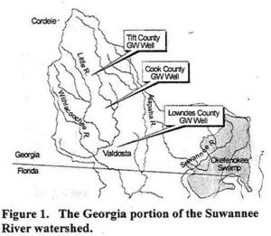
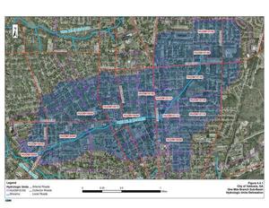
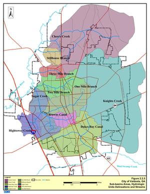
Those schedule changes are mentioned in the most recent Valdosta News. It does not, however, say which watersheds the various spills affect. I have added * for Alapaha River watershed and ** for Withlacoochee River watershed. It’s not that hard, and Valdosta has a water management plan that spells this all out, with maps. One Mile Branch** and Two Mile Branch** flow into Sugar Creek**, which goes into the Withlacoochee River**. Knights Creek* goes into Mud Creek* which goes into the Alapahoochee* River and then the Alapaha River*, eventually joining the Suwannee River in Florida, as does the Withlacoochee. Valdosta Utilities and Public Relations know all that. But why should every citizen, Continue reading

WWALS Water Trail trailers 7PM tonight at VSU CAUSES mini-film festival 2016-01-23

April Huntley submitted a 90-second video about the Alapaha River Water Trail, and Gretchen Quarterman sent one in about the BIG Little River Paddle Race on the Withlacoochee and Little River Water Trail. Come cheer for them and other local community entries, 7PM tonight, Bailey Auditorium, VSU, Valdosta, Lowndes County, Georgia.

-jsq

You can join this fun and work by becoming a WWALS member today!

Water Resources of the upper Suwannee River Watershed

Even the trend of sinking groundwater levels hasn’t changed a lot in the Georgia parts of WWALS’ watersheds of the Withlacoochee, Alapaha, and upper Suwannee Rivers. Figure 1: Georgia Watersheds Thanks to Tom Potter for the pointer, and we’re inviting someone to talk about this subject at the Withlacoochee and Little River Water Trail Workshop at VSU February 27th, 2016.

WATER RESOURCES OF THE UPPER SUWANNEE RIVER WATERSHED, by Mary M. Davis1 and David W. Hicks2,

1 Ecologist, Continue reading

Video: WWALS outings on Chris Beckham drive-time radio WVGA 105.9 FM 7:30 AM 2016-01-15

Here’s WWALS video of the radio interview this morning on WVGA 105.9 FM. It’s an invitation to tomorrow morning’s events, both at 10AM:

Chris also got me to say a few words about why WWALS formed in the first place, and why you should all join WWALS; it has to do with the 700-year flood in 2009.

Plus some plugs for Valdosta’s wastewater fixes and their recent LiDAR flight.

The one thing I realized on the way out I forgot to mention, the one item that caused me to schedule this interview, was the workshop at VSU February 27th about the Withlacoochee and Little River Water Trail, featuring the visual beauty of all WWALS’ rivers in an art exhibit and silent auction, the geology on display by Dennis Price, and the remains of past people and cultures still visible along the river by Tom Baird.

Looking forward to seeing you tomorrow morning on the Little River, or other WWALS members look forward to seeing you tomorrow morning on the Suwannee River. If not tomorrow, there’s plenty more to do on our beautiful south Georgia and north Florida blackwater rivers!

Here’s the video:

Continue reading

WWALS outings on Chris Beckham drive-time radio WVGA 105.9 FM 7:30 AM 2016-01-15

Everybody listens to the radio in the car on the way to work, and Friday morning 8:30 AM I’ll be talking about paddling this Saturday morning 10AM on the Little River from GA 122 between Hahira and Barney to Lawson Millpond Road; it’s a nice brief 2.5 hour paddle along the Brooks-Lowndes County river border: you can do it!

When: 7:30AM Friday January 15th 2016

Where: 105.9 FM WVGA, Valdosta, Lowndes County, Georgia

What: John S. Quarterman, president of WWALS Watershed Coalition, Inc., on Chris Beckham drive-time radio show

How: Continue reading

Staten Road bridge to Langdale Park, Withlacoochee River through Valdosta 2016-03-20

Update 2016-03-24: Pictures.

Explore the Withlacoochee River as it meanders thru the edge of Valdosta, past Shadrick Sink, Cherry Creek, and under North Valdosta Road, Back along the bank on the Withlacoochee and Little River Water Trail. Wave at some of your friends in the houses nearby.

Update 2016-03-19: Yes, there are potholes at Staten Road Bridge, but that never stopped us from paddling. Come on down!

Update 2016-03-14: Langdale Park will be closed, but VLPRA will let us in.

Event: facebook or meetup.

When: 9AM Sunday March 20th 2016

Put in: Staten Road Bridge, 7.1 miles north of Valdosta, Lowndes County.

Take out: Langdale Park Boat Ramp, 3781 N. Valdosta Rd., Valdosta, GA 31602, Lowndes County.

Distance: About 5 miles

Duration: About 2.5 hours

Shuttle: About half an hour

Take out: Langdale Park Boat Ramp

Also passing: Bay Branch, Sermons Branch (if that is its real name), Withlacoochee Slough at Cherry Creek, Cherry Creek Sink, and Stillhouse Branch coming out of Valdosta Country Club.

Responsible party: Chris Mericle

Local host: John S. Quarterman

Directions from Valdosta: head north on Ashley Street, turn left on Oak Street Extension,

Directions from I-75: take exit 22, go east on North Valdosta Road, left on Perimeter Road, left on Oak Street, continue onto Staten Road, cross Orr Road, and after about 2/3 of a mile just before the bridge, turn off to the right.

Map from Staten Road Bridge to Langdale Park Boat Ramp

Too low: we’re guessing 2 feet on either the at Skipper Bridge or US 41 gauges.

Too high: flood stage is 15 feet at Skipper Bridge and at US 41.

This outing is Free! But we encourage you to join WWALS today to support our fun outings and important work: /donations/. See our newsletters, and the press Releases and news. And consider joining the Withlacoochee and Little River Water Trail Committee.

Backup in case of low or high water:

Where: Ray’s Millpond

When: 9AM March 20th 2016

Directions: From Valdosta, north on Bemis Road (GA 125) to Ray City, right on Jones St. to boat ramp.

Coming up even sooner:

For more outings and events as they are posted, see the WWALS calendar.

-jsq

You can join this fun and work by becoming a WWALS member today!

HAAs in Valdosta drinking water 2015-12-21

Valdosta has a water treatment byproduct over the recommended limit in its drinking water. Janet McMahan supplied the image below of part of a notice, which says there’s no cause for alarm at the moment:

HAA5 Warning

There is nothing you need do at this time. These violations do not pose Continue reading

EPA stepped back, while opposition ramps up against Sabal Trail fracked methane pipeline

FOR IMMEDIATE RELEASE

EPA stepped back, while opposition ramps up against Sabal Trail fracked methane pipeline

Hahira and Albany, Georgia, December 18, 2015— (PDF) Mysteriously contradicting a substantive October letter from U.S. Environmental Protection Agency (EPA) Region 4 in Atlanta, a different EPA branch last Friday sent a brief and sketchy letter to the U.S. Army Corps of Engineers uncritically accepting what Sabal Trail’s attorney’s told it, even as multiple environmental and landowner organizations filed objections with the Corps and multiple state agencies against that invading natural gas pipeline.

“I smell a skunk,” said Frank Jackalone, senior organizing manager, Sierra Club of Florida.

Tim Carroll, Valdosta City Council member, said, “I don’t understand how EPA and FERC can say there will not be a negative impact on our environment, aquifer, streams and rivers. A number of experts testified and spoke up saying the likelihood is very high that there could be damage to the aquifer and the environment. Why would we want to allow this to happen, to run the risk of seriously degrading one of the best water resources in the world.,” Valdosta, Moultrie, and Albany, the three biggest cities along the pipeline path in Georgia, all passed resolutions against Sabal Trail, as did the counties of Terrell, Dougherty, Colquitt, Brooks, and Lowndes, in Georgia, and Hamilton and Suwannee Counties in Florida.

“The one government agency actually defending our drinking in the Floridan Aquifer and the many rivers in Georgia and Florida just stifled itself,” Continue reading

Sea level gage reports: all USGS gages in WWALS territory in Georgia

All the Suwannee River Basin USGS gages in Georgia just got a new flood level reporting system (except they missed one). Locator Map: Central South Georgia USGS Gages They’ve added a level measurement from sea level, probably not coincidentally about the same as the Florida gages added a level measurement from dry riverbed, so both Georgia and Florida gages now have both measurements. This actually does not affect the WWALS level charts for the Withlacoochee and Little River Water Trail nor for the Alapaha River Water Trail, because those continue to display water levels from dry riverbed. To see this change at all, you have to drill down to the USGS detail pages, for example on the Withlacoochee River at Skipper Bridge Road in Georgia, or near Pinetta, Florida.

National Weather Service Weather Forecast Office, Tallahassee, FL, unknown date, Suwannee River Basin Datum Changes in South Central Georgia,

Starting on October 14, 2015, the National Weather Service in Tallahassee and Jacksonville will make adjustments to the reporting method for water level in the Suwannee River System. This includes river gages in the following rivers or creeks: Continue reading

Two Valdosta sewer spills in Withlacoochee River watershed

What crosses Lee Street and Gornton Road heading to the Withlacoochee River? Aerial Map: One Mile Branch HUCs One Mile Branch and Sugar Creek, but you wouldn’t know that from Valdosta’s press releases.

Valdosta PR 27 October 2015, Grease Blockage Causes Small Sanitary Sewer Spill in City,

At approximately 11:30 a.m. on Oct. 26, 2015, the City of Valdosta Utilities Department responded to a grease blockage that caused Continue reading