Category Archives: Maps

Stop Sabal Trail fracked gas pipeline; invest in solar –John S. Quarterman in Citrus County Chronicle 2016-12-25

Here’s a Christmas present for pipeline opponents and solar power proponents.

John S. Quarterman John S. Quarterman, Citrus County Chronicle, other voices, 25 December 2016, Stop gas pipeline; invest in solar,

Sabal Trail and FDEP assured us there would be no problems drilling a 36-inch natural gas pipeline through the fragile karst limestone under the Suwannee River and the Withlacoochee (south) River in Florida, yet already Sabal Trail’s pilot hole under the Withlacoochee (north) River in Georgia caused a frac-out of drilling mud into the river and a sinkhole. The U.S. Army Corps of Engineers should halt construction and do a Supplemental Environmental Impact Statement.

When I happened to fly over the Withlacoochee (north) River frac-out, I also saw Continue reading

Crowdsourcing pictures of Sabal Trail path

Update 2016-11-29: Added to this google map: WWALS aerials of Gilchrist County, and Sabal Trail alignment maps localized by LAKE for Mitchell, Colquitt, Brooks, and Lowndes Counties, Georgia, and Hamilton, Suwannee, and Gilchrist Counties, Florida to just north of Bell, FL.

Update 2016-11-04: Now with Sabal Trail route digitized through Gilchrist, Alachua, and part of Levy Counties, plus part of the Citrus County line.

Signs, silt fences, backhoes in wetlands: you can log pictures on a map of anything going on at a Sabal Trail construction site from your mobile phone, tablet, or laptop. Already posted your pictures on the web? Link them into the map. Here’s how.

You’ve seen many pictures posted by WWALS, taken on the ground and in the air, and linked into a google map (which also has Sabal Trail’s alignment maps linked in).

Here’s another google map, to which more people can add pictures.

If you want to add pictures to this new crowdsourcing google map, you need to: Continue reading

All 527 Sabal Trail alignment maps from April 2016

Courtesy of Lowndes Area Knowledge Exchange, you can now see small, big, huge, and PDF versions of all 527 alignment maps Sabal Trail filed with FERC in April 2016: follow this link.

[STA. 11870+00 TO STA. 11923+00, (UT OKAPILCO CREEK), 11881+44 CL SPAIN ROAD, 11871+70 CL GOLDING ROAD, BROOKS COUNTY, GEORGIA]

Having these maps online like this makes it easier to see what’s in them. Sabal Trail told FERC Okapilco Creek was not among the streams for which the Georgia legislature denied river-drilling easements (and for which Sabal Trail got the easements later anyway by suing the state in county Superior Courts). Yet Sabal Trail’s alignment maps from April 2016 seem to say that fracked methane pipeline crosses Okapilco Creek a couple of times in Brooks County, Georgia.

Here’s one of those times, in which the road names don’t match Continue reading

Sabal Trail maps digitized

Update 2019-03-19: The google map now includes Florida Southeast Connection (FSC) and FPL’s Martin County to Riviera Beach (MR-RV) pipeline to the sea, which FPL in 2018 got FPSC and FERC to roll into FSC. See also Stop FERC Shirking LNG Oversight.

South Georgia and north Florida 
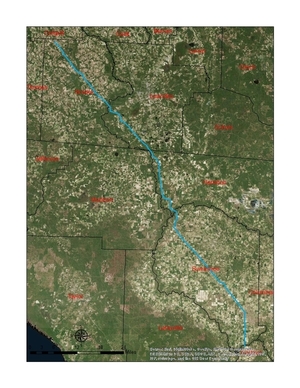
Update 2016-12-13: The google map now includes the Sabal Trail path digitized for all of Georgia and to the end of the line in Florida south of Orlando.

Update 2016-11-29: In the google map, extended the Sabal Trail alignment maps localized by LAKE for Mitchell, Colquitt, Brooks, and Lowndes Counties, Georgia, and Hamilton, Suwannee, and Gilchrist Counties, Florida to just north of Bell, FL, plus on the crowdsourcing map, WWALS 
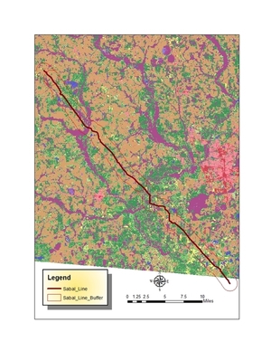
aerials of Gilchrist County.

Update 2016-11-03: Added to the google map digitized path and maps for Gilchrist, Alachua, and part of Levy Counties, FL.

Update 2016-10-31: Added to the google map: Aerials: Suwannee, Ocholockonee, Withlacoochee, Santa Fe Rivers, Okapilco Creek, Sabal Trail Moultrie CY3-6 @ WWALS Southwings 2016-10-22.

Update 2016-10-30: The google map now has all Sabal Trail’s alignment maps from 7 April 2016 linked in for (part of Gilchrist 2016-11-29), Suwannee and Hamilton Counties, FL and Lowndes, Brooks, Colquitt, and Mitchell Counties, GA. Aerial pictures from the WWALS Southwings flight of October 22nd 2016 are also linked in, starting with US 84 HDD Withlacoochee River and US 129 HDD Santa Fe River.

Update 2016-09-14: All 527 alignment maps Sabal Trail filed with FERC in April 2016, in small, big, huge, and PDF formats, courtesy of Lowndes Area Knowledge Exchange (LAKE).

Update 2016-09-23: Added Depressions within 1 mile of Sabal Trail in Hamilton, Madison, and Suwannee Counties, Florida. The pipeline path doesn’t go through Madison County, but it comes closer than a mile, and not even two miles from Madison Blue Spring.

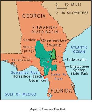
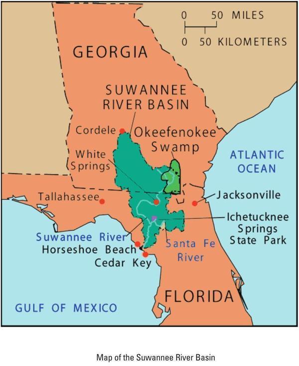
These maps show the path Sabal Trail is gouging its fracked methane pipeline through south Georgia and north Florida, with comparisons to some geological features, including Okapilco Creek, Withlacoochee River, Suwannee River, Suwannacoochee Spring, Falmouth Spring, the Cathedral Cave System, and numerous karstic features, some of them sinkholes.

Brooks and Lowndes Counties, GA This digitizaiton is thanks to Continue reading

What WWALS Does: watershed advocacy from outings and water trails to wastewater and pipelines

Water trails, wastewater, corporate agriculture, solar power, fracking, and pipelines: WWALS works with many issues in many ways, as part of our advocacy for conservation and stewardship through education, awareness, environmental monitoring and activities such as our monthly paddle outings. McIntyre Spring snorkel 30.6416626, -83.3660889

Here’s an introduction to WWALS for the many new members and even more people following WWALS on facebook and twitter.

WWALS Watershed Coalition, or WWALS for short, is an IRS 501(c)(3) nonprofit corporation about everything related to water in the watersheds Continue reading

Map of Suwannee River Basin

Map of Suwannee River Basin Yet another map, this one from the Suwannee River Basin and Estuary Integrated Science Workshop, USGS, 22-24 September 2004, Cedar Key, Florida, Compiled by Brian Katz and Ellen Raabe. Here are the slides from that workshop.

This map is a bit odd in that it does not show the biggest city in the entire Suwannee River Basin.

However, it shows nearby larger cities. I never really realized Jacksonville is closer than Tallahassee to most of the Basin.

Map of Suwannee River Basin

For more maps, see the WWALS Suwannee River Basin web page.

-jsq

You can join this fun and work by becoming a WWALS member today!

Map of American Rivers by Nelson Minar

Here’s a map of all rivers in the U.S. by Nelson Minar. Lower 48 U.S. It actually covers the lower 48 states and is pretty impressive at that scale. Plus you can zoom in.

Gulf and south Atlantic

Here you can see rivers running to the Gulf start all the way up Continue reading

WWALS invites Army Corps of Engineers to inspect and investigate Sabal Trail

Sent 5 April 20156. PDF.

Transco-atlantic-sunrise.jpg

You can join this fun and work by becoming a WWALS member today!

Continue reading

WWALS Watersheds google map

Update 2020-01-25: Superseded by WWALS Suwannee River Basin Map and All Landings in the Suwannee River Basin, now that Suwannee Riverkeeper territory includes the entire Basin plus Estuary, since Waterkeeper Alliance agreed to add the Ichetucknee and Santa Fe Rivers on September 26, 2019.

Update 2017-10-30: River flowlines.
Update 2017-10-08: Better colors plus a Suwannee River Basin map.
Update 2017-04-13: Since December 2016 WWALS Watersheds have included the Lower Suwannee River HUC 03110205 and the Suwannee River Estuary, approved by Waterkeeper Alliance the same time as the license for Suwannee RIVERKEEPER®.

Small, WWALS Watersheds Map Legend

Click on this link for an interactive google map of WWALS watersheds.

The images you see here are static screenshots of that google map. Follow the link above for the actual google map.

The watershed outlines are from Continue reading

Florida Well Salinity Study

Update 2017-05-18: Salt water intrusion inland is worse than you think, including the “Apalachicola salinity feature” up to the GA-FL line and east through Lowndes County, with a special additional brackish Valdosta feature. See Revised Hydrogeologic Framework of the Floridan Aquifer System 2016-03.

Update 2016-02-22: Fixed URLs for DEP files.

Salt water and other solids are coming up in Florida wells far inland from the sea, Sulfate in Status Network Wells (All Aquifers) Modeled Using Inverse Distance Weighting right up to the state line, and it probably doesn’t stop there. The problem is worse on the coasts and in south Florida, but north central Florida is not immune, judging by these preliminary maps by the Florida Department of Environmental Protection. Likely culprits would seem to include overpumping. Continue reading