
Follow this link for videos, more pictures, and a google map.

Follow this link for videos, more pictures, and a google map.
My phone’s pedometer said I walked four miles of the six miles of this section of the Little River, with many fish, two white birds, lots of sand bars, some eroded bluffs, not a lot of trash after we got beyond the GA 76 bridge, and only one spot of invasive species (Japanese climbing fern).

This section would be better with about half a foot more water. The USGS GA 122 Little River gage showed about 3.71 feet for July 10th 2016, so let’s say at least 4.2 feet would be good. This is because there are many sand bars, including one directly upstream from the GA 122 bridge, where the water level is much closer to zero when that gage says 3.71.
Following up a report, Continue reading
Update 2019-03-19: The google map now includes Florida Southeast Connection (FSC) and FPL’s Martin County to Riviera Beach (MR-RV) pipeline to the sea, which FPL in 2018 got FPSC and FERC to roll into FSC. See also Stop FERC Shirking LNG Oversight.
 Update 2016-12-13: The google map now includes the Sabal Trail path digitized for all of Georgia and to the end of the line in Florida south of Orlando.
Update 2016-11-29: In the google map, extended the Sabal Trail alignment maps localized by LAKE for Mitchell, Colquitt, Brooks, and Lowndes Counties, Georgia, and Hamilton, Suwannee, and Gilchrist Counties, Florida to just north of Bell, FL, plus on the crowdsourcing map, WWALS aerials of Gilchrist County.
Update 2016-11-03: Added to the google map digitized path and maps for Gilchrist, Alachua, and part of Levy Counties, FL.
Update 2016-10-31: Added to the google map: Aerials: Suwannee, Ocholockonee, Withlacoochee, Santa Fe Rivers, Okapilco Creek, Sabal Trail Moultrie CY3-6 @ WWALS Southwings 2016-10-22.
Update 2016-10-30: The google map now has all Sabal Trail’s alignment maps from 7 April 2016 linked in for (part of Gilchrist 2016-11-29), Suwannee and Hamilton Counties, FL and Lowndes, Brooks, Colquitt, and Mitchell Counties, GA. Aerial pictures from the WWALS Southwings flight of October 22nd 2016 are also linked in, starting with US 84 HDD Withlacoochee River and US 129 HDD Santa Fe River.
Update 2016-09-14: All 527 alignment maps Sabal Trail filed with FERC in April 2016, in small, big, huge, and PDF formats, courtesy of Lowndes Area Knowledge Exchange (LAKE).
Update 2016-09-23: Added Depressions within 1 mile of Sabal Trail in Hamilton, Madison, and Suwannee Counties, Florida. The pipeline path doesn’t go through Madison County, but it comes closer than a mile, and not even two miles from Madison Blue Spring.
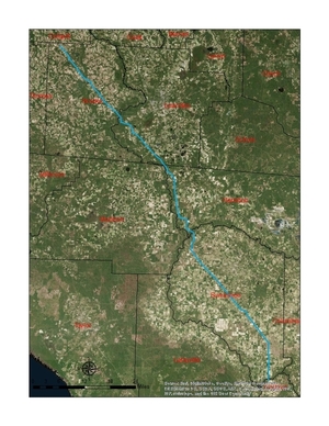
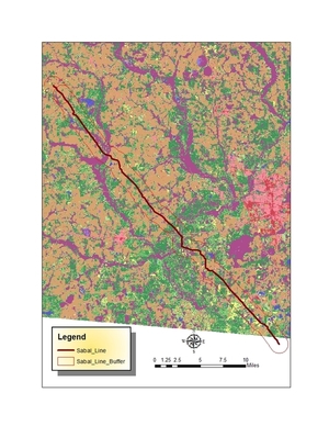
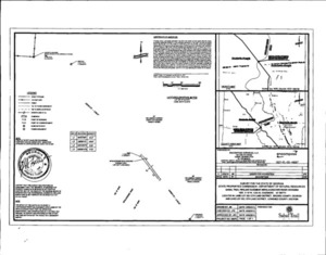
These maps show the path Sabal Trail is gouging its fracked methane pipeline through south Georgia and north Florida, with comparisons to some geological features, including Okapilco Creek, Withlacoochee River, Suwannee River, Suwannacoochee Spring, Falmouth Spring, the Cathedral Cave System, and numerous karstic features, some of them sinkholes.
 This digitizaiton is thanks to Continue reading

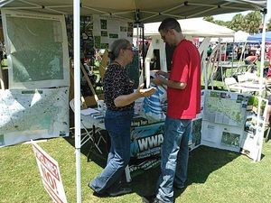
WWALS will have a booth at the South Georgia Pride Festival Saturday, September 17th. We will share information about our activities, programs and activism with the local community.
Waterkeeper Alliance and Affilates support equality, particularly “we know equality and human rights are intrinsic to environmental values.”
South Georgia Pride is open to the community and family friendly and we invite you to come and visit us from 12-7
at John Saunders Park, 1151 River St.,
Valdosta, GA 31601.

-gretchen
The Bell brothers, Flint Riverkeeper, and John S. Quarterman of WWALS
all against Sabal Trail in an Atlanta publication.
 Come on down to the Suwannee River Tuesday near Jasper, FL
or to the Withlacoochee River between Quitman and Valdosta, GA 9AM Saturday Sep. 17th to see
for yourself what we’re protecting and to say your piece on video.
Come on down to the Suwannee River Tuesday near Jasper, FL
or to the Withlacoochee River between Quitman and Valdosta, GA 9AM Saturday Sep. 17th to see
for yourself what we’re protecting and to say your piece on video.
Gloria Tatum, Atlanta Progressive News, 12 September 2016, Proposed SabaL Gas Pipeline runs through aquifer, wetlands, sinkhole territory, Continue reading
8AM Friday morning WWALS will be on Chris Beckham’s drive-time radio show.
![]() WWALS president John S. Quarterman will be talking about
Saturday morning’s Suwannee River paddle outing
and other outings upcoming on the Alapaha and Withlacoochee Rivers,
along with other developments on the
Alapaha River Water Trail and the
Withlacoochee and Little River Water Trail,
along with
many other things WWALS does.
Plus what you can do about
the FERC rubberstamp of the Sabal Trail fracked methane pipeline
drilling under the Withlacoochee and Suwannee Rivers.
WWALS president John S. Quarterman will be talking about
Saturday morning’s Suwannee River paddle outing
and other outings upcoming on the Alapaha and Withlacoochee Rivers,
along with other developments on the
Alapaha River Water Trail and the
Withlacoochee and Little River Water Trail,
along with
many other things WWALS does.
Plus what you can do about
the FERC rubberstamp of the Sabal Trail fracked methane pipeline
drilling under the Withlacoochee and Suwannee Rivers.
When: 8:00 7:30AM Friday September 2nd 2016
Where: Continue reading
 WWALS will have a booth at The Happening tomorrow (Thursday, August 25th) at which new and returning students to Valdosta State University (VSU) have an opportunity to learn about both the local community and campus clubs. We will be sharing a booth with Students Against Violating the Environment (S.A.V.E) and look forward to collaborating with them on projects throughout the year.
The Happening is open to the community and we invite you to come an visit us from 1-4 on the front lawn at VSU.
-gretchen
You can join this fun and work by becoming a WWALS member today!
0.03 acres under the Withlacoochee River sold by the State of Georgia to Sabal Trail, operated by Spectra Energy of Houston, Texas, for $5,000, or $166666.66/acre.
 That easement must be very valuable to Sabal Trail.
But it’s more valuable to us who live here and swim, fish, and boat on that river
and drink from the Floridan Aquifer.
If we’d known this was going on, some of us might have filed other documents in this case.
That easement must be very valuable to Sabal Trail.
But it’s more valuable to us who live here and swim, fish, and boat on that river
and drink from the Floridan Aquifer.
If we’d known this was going on, some of us might have filed other documents in this case.
Also, I would have thought 666 once would have been enough.
Here are some things you can do to help stop this boondoggle, and background about why this pipeline is a bad idea when there are already more solar jobs than in oil and gas extraction, and Georgia is the fastest-growing U.S. solar market.
Here’s the judge’s final order (PDF), followed by the other court documents in this case: Continue reading
They didn’t even bother to fill in the year on the date, and “File with original letter”. Here’s what the Corps wrote (PDF) in response to Madison County’s request for a Supplemental Environmental Impact Statement (SEIS) about Sabal Trail.
File with
original letterDEPARTMENT or THE ARMY
JACKSONVILLE DISTRICT CORPS 0F ENGINEERS
POST OFFICE BOX 4970
JACKSONVILLE, FLORIDA 32232-0019July 29, 201
Reply to attention of
Regulatory Division
North Permits Branch
Jacksonville Permits Section
SAJ-2013-03030Madison Board of County Commissioners
Attn: Mr. Brian Kauffman, County Coordinator
Post Office Box 539
Madison, Florida 32341Dear Mr. Kauffman:
Please accept this correspondence as Continue reading
This request for a Supplementary Environmental Impact Statement (SEIS), mentioning Madison Blue Spring in particular, was sent July 18th or 19th 2016, one copy to each of the Corps addresses. (PDF). That’s the fourth Florida county to make such a request, after Hamilton, Suwanee, and Marion Counties. The Corps already responded to Madison County.
Board of County Commissioners
Madison County, Florida
Jacksonville Permits Section
U.S.A.C.E. Regulatory Division
Attn: Mark R. Evans,
Senior Project Manager,
Post Office Box 4970
Jacksonville, Florida 32232Commander, U.S.A.C.E.,
Savannah District
Attn: Mr. Terry C. Kobs
1104 N. Westover Boulevard, Unit 9
Albany, GA 31707U.S.A.C.E.
Mobile District Reg. Div.
Montgomery Field Office
Attn: Mr. James S. Cherry II
605 Maple Street
Building 1429 Room 105
Maxwell AFB, AL 36112-6017
Norman C. Bay, Chairman Continue reading