Category Archives: Sink

Cherry Creek & Stillhouse Branch, Lift Station, Sinks, Withlacoochee River

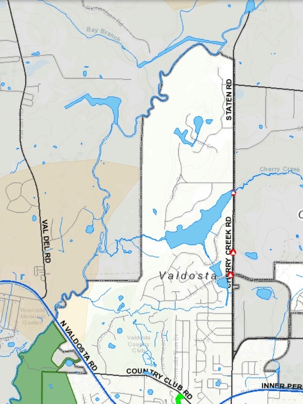
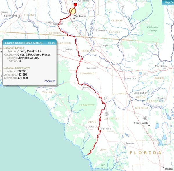
Why should anyone downstream care about an obscure creek north of Valdosta? Because it runs past sinkholes that leak into the Floridan Aquifer, into the Withlacoochee River, then into the Suwannee River, then into the Gulf of Mexico, going by all seven of the downstream Florida counties that passed resolutions asking the state of Florida to do something about Valdosta wastewater, not to mention neighborhoods and wetlands closer to the recent Cherry Creek Lift Station sewage leak, which was at least smaller than previous spills.

Cherry Creek, Withlacoochee River, Suwannee River, Gulf of Mexico

Cherry Creek, Withlacoochee River, Suwannee River, Gulf of Mexico

The orange red-circled disk shows Continue reading

Sinkhole half a mile from FPL pipeline, FSC 2017-09-11

Hurricane Irma caused a sinkhole that destroyed the entrance to a subdivision less than half a mile from an FPL pipeline to the sea, about two miles from Floridian Natural Gas (FlING), and about seven miles from the end of Florida Southeast Connection (FSC). What other sinkholes appeared, and were any under that pipeline, FSC, Sabal Trail, or Transco?

Sinkhole, FPL pipeline, FLiNG, FSC
Sinkhole, FPL pipeline, FLiNG, FSC; map by John S. Quarterman for WWALS.
Click on this link for the interactive google map.

Julius Whigham II, Palm Beach Post, 12:39 a.m. Monday, Sept. 11, 2017, Hurricane Irma: Storm creates sinkhole in western Martin community, Continue reading

WWALS at VSU Learning in Retirement 2017-08-31

Come ask Gretchen questions this Thursday morning, 10-11AM, at VSU’s Continuing Education building in midtown Valdosta.

When: 10AM to 11AM, Thursday, August 31, 2017

Where: VSU Continuing Education
903 N Patterson St, Valdosta, Georgia 31698

Event: facebook

Gretchen Quarterman, Executive Director, WWALS Watershed Coalition
Gretchen Quarterman speaking at a WWALS public meeting at VSU last spring

WWALS will be offering an interactive lecture at Valdosta State Learning in Retirement Fall Session. We will talk about the watershed of the Suwannee Basin, the Floridan Aquifer, current challenges, and how together we can make sure our water is swimmable, fishable, and drinkable.

Continue reading

Stop Sabal Trail fracked gas pipeline; invest in solar –John S. Quarterman in Citrus County Chronicle 2016-12-25

Here’s a Christmas present for pipeline opponents and solar power proponents.

John S. Quarterman John S. Quarterman, Citrus County Chronicle, other voices, 25 December 2016, Stop gas pipeline; invest in solar,

Sabal Trail and FDEP assured us there would be no problems drilling a 36-inch natural gas pipeline through the fragile karst limestone under the Suwannee River and the Withlacoochee (south) River in Florida, yet already Sabal Trail’s pilot hole under the Withlacoochee (north) River in Georgia caused a frac-out of drilling mud into the river and a sinkhole. The U.S. Army Corps of Engineers should halt construction and do a Supplemental Environmental Impact Statement.

When I happened to fly over the Withlacoochee (north) River frac-out, I also saw Continue reading

Pictures: Alapaha and Dead River Sinks 2016-11-06

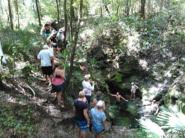
the Alapaha River sink, 30.5855189, -83.0528064 A very scenic hike to some of the most unusual geological features in all of Florida: the Alapaha River Sink and the Dead River Sink. We walked over beds of 50-million-year-old fossilized oysters, above all our drinking water in the Floridan Aquifer. See many pictures and a few videos of the sights, and a google map of the sites.

Practicing Geologist Dennis Price led us by the scenic route on this hike, explaining the karst geology on display, which underlies all of north Florida and south Georgia, containing our drinking water in the Floridan Aquifer. Dennis and hike organizer Chris Mericle recommend making this very unusual area a state park.

The Alapaha River goes underground here unless it has a lot of water, which usually this time of year and right now it does not.

[Don't fall into the Devil's Den, 30.5855189, -83.0528064]
Don’t fall into the Devil’s Den, 30.5855189, -83.0528064

Update 2022-11-17: The Jennings Gauge read 61.70′ NAVD88.

Until recently nobody knew for sure Continue reading

From the air: US 84 HDD Withlacoochee River Sabal Trail 2016-10-22

Update 2016-10-24: Questions filed with FERC in Docket CP15-17 as Accession Number 20161024-5049 and emailed to USACE and GA-EPD (PDF).

Extreme closeup yellow in Withlacoochee River, 30.7952780, -83.4524840 What is that yellow thing in the river, Sabal Trail? Is that a sinkhole you’ve marked at the Lowndes County HDD site? And does blue pipe mean thinner for rural areas like your executive from Houston told us in WWALS v Sabal Trail & FDEP?

FERC gave you permission to Continue reading

Hike to Dead River Sink from Alapaha River 2016-11-06

An easy hike following Alapaha River as it flows into the Dead River and disappears into the Dead River Sink: you don’t see this just anywhere!.

Update 2016-10-15: Be aware the path does get steep and rough towards the sink, and there are mosquitoes and chiggers.

Bring water, a snack, and bug repellent.

No boat required. Really: you don’t want to try to boat up the Dead River. But you do want to see the Dead River Sink.

When: 10AM Saturday November 6th 2016

Duration: 2-3 hours

Where: Jennings Bluff Landing, 30.579864, -83.039308

Event: facebook, meetup.

This outing is Free! But we encourage you to join WWALS today to support our fun outings and important work: /donations/. Continue reading

What WWALS Does: watershed advocacy from outings and water trails to wastewater and pipelines

Water trails, wastewater, corporate agriculture, solar power, fracking, and pipelines: WWALS works with many issues in many ways, as part of our advocacy for conservation and stewardship through education, awareness, environmental monitoring and activities such as our monthly paddle outings. McIntyre Spring snorkel 30.6416626, -83.3660889

Here’s an introduction to WWALS for the many new members and even more people following WWALS on facebook and twitter.

WWALS Watershed Coalition, or WWALS for short, is an IRS 501(c)(3) nonprofit corporation about everything related to water in the watersheds Continue reading

SRWMD listens about Sabal Trail easements, chooses unfortunately, yet offers assistance 2016-07-12

Attached are my comments to the SRWMD Governing Board today (July 12th 2016) in regards to the Sabal Trail crossing site over the Falmouth Cathedral Cave System.

I was the first to speak at the public comment period followed by Jim Tatum then Merrillee. Jim and Merrillee echoed my concerns. The three of us set the tone for the meeting! The Board was interested and engaged asking questions to better understand what impacts Sabal Trail poses for the cave system and the District. About Time!


Merrillee Malwitz-Jipson of Sierra Club Florida speaking to SRWMD 2016-07-12
Photo credit: Our Santa Fe River

Executive Director, Noah Valenstein offered to personally call the ACE to request Continue reading

Two new reasons for a SEIS: WWALS to USACE, GA-EPD, and FERC 2016-07-08

LiDar Filed Friday as FERC accession number 20160708-5096, http://elibrary.ferc.gov/idmws/file_list.asp?document_id=14476452, “Two new reasons for a USACE Supplemental Environmental Impact Statement and a halt to Sabal Trail permits; see also accession numbers 20160708-5089 and 20160708-5088, by WWALS Watershed Coalition, Inc. under CP15-17.” (PDF) Continue reading